Exploring the Klingenbergstraße: A Motorcyclist’s Guide to Upper Austria’s Rolling Roads
Locals know best!
If you travel this road often or live close by you will be given a chance to provide your valuable rating soon! Sign in and stay connected.Location and Route Overview
Klingenbergstraße is situated in the northern part of Austria, within the state of Upper Austria. The road connects several small settlements, including Ober St.Thomas, Klingenbergstraße, Teichsiedlung, Mitter St.Thomas, and Am Sonnenhang, forming a loop that returns to Ober St. Thomas. The region is characterized by rolling countryside, interspersed with forests and agricultural land. The proximity to the Bohemian Forest and the tranquil rural landscape make this area a pleasant destination for riders seeking a less-traveled route. An interactive map showing the precise route of Klingenbergstraße can be found at the end of this article.
Road Characteristics and Riding Experience
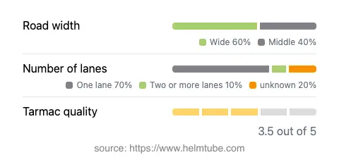
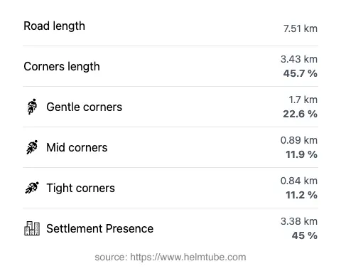
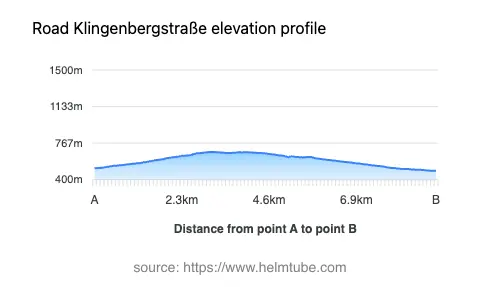
Klingenbergstraße extends for approximately 7.5 km (4.7 miles), offering a moderately curvy ride that is well-suited for both novice and experienced motorcyclists. The road surface is asphalt, with a quality that can be described as fair to good, providing a generally comfortable ride with some sections that may require extra attention due to minor imperfections. The route features a mix of road widths, with the majority (about 57%) being wide enough for easy passing, while narrower stretches (about 4%) demand careful navigation. Most of the road is single-lane, with a small proportion offering two lanes, which can be helpful for overtaking. The elevation ranges from 489 m (1,604 ft) to 678 m (2,224 ft), presenting gentle climbs and descents rather than steep gradients. The maximum speed limit is 50 km/h (31 mph), reflecting the road’s passage through inhabited areas and its rural character.
Points of Interest and Attractions
While Klingenbergstraße is primarily a local connector, it does run alongside a notable viewpoint, offering riders the opportunity to pause and take in the surrounding landscape. The area’s rural charm is complemented by its proximity to the Bohemian Forest, a region known for its natural beauty and outdoor recreation opportunities. The settlements along the route, such as Ober St.Thomas and Mitter St.Thomas, provide glimpses into traditional Austrian village life. Riders interested in exploring further can find additional attractions in the broader Upper Austria region, including historic towns and nature reserves.
Road Closures and Seasonal Considerations
There are no known permanent closures of Klingenbergstraße to motorcycles. However, as with many rural roads in Austria, temporary closures may occur due to roadworks, local events, or adverse weather conditions, particularly during the winter months when snow and ice can make riding hazardous. It is advisable to check local traffic updates or consult the ASFINAG traffic reports before planning a trip, especially outside the main riding season.
Tolls, Fees, and Practical Information
Klingenbergstraße does not currently require a toll or entrance fee for motorcycles. Riders should be aware that toll conditions in Austria may change, and it is always prudent to verify the latest information before traveling. For comprehensive details on road tolls and vignette requirements in Austria, refer to the ASFINAG vignette information page. Fuel stations and amenities are limited along the route, so planning ahead is recommended for longer journeys.
Explore the Region: Roads Close By
Discover more amazing roads located near the route featured in this article. The list below highlights nearby routes that are perfect for extending your ride or planning your next adventure.
Ride the Best: Austria’s Top Motorcycle Roads
These are the best motorbiking roads in Austria. The list below shows links to articles about top-rated motorcycle routes in the country. Explore the most popular roads in Austria and plan your next unforgettable motorbike adventure.