Exploring Austria’s Rechberger Straße: A Motorcyclist’s Guide
Locals know best!
If you travel this road often or live close by you will be given a chance to provide your valuable rating soon! Sign in and stay connected.Location and Overview of Rechberger Straße
Rechberger Straße is situated in the northern part of Austria, within the state of Upper Austria. The road connects several settlements, including Windhaag and Perg, and traverses a region characterized by rolling hills and a mix of agricultural and forested areas. The route is easily accessible from the town of Perg, which serves as both the nearest major settlement to the starting and ending points of the road. For those planning their journey, an interactive map showing the precise route of Rechberger Straße can be found at the end of this article.
Road Details and Riding Experience
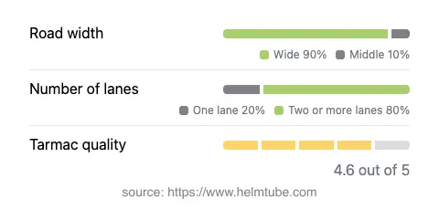
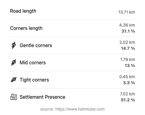
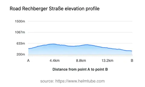
Rechberger Straße extends for approximately 13.7 km (8.5 miles), offering a ride that is moderately curvy, making it suitable for riders who appreciate a balance between relaxed cruising and engaging turns. The road surface is asphalt and is generally regarded as being of very good quality, providing a smooth and predictable riding experience. The majority of the route features two lanes (about 75%), with the remainder consisting of single-lane sections. In terms of width, the road is predominantly wide (about 87%), with a small portion being of medium width. The elevation ranges from 338 m (1,109 ft) at its lowest point to 609 m (1,998 ft) at its highest, offering gentle elevation changes rather than steep climbs or descents. The maximum speed limits along the route are 70 km/h (43 mph) and 50 km/h (31 mph), depending on the specific section.
Settlements and Points of Interest Along the Route
The road passes through or near several settlements, including Windhaag and Perg, as well as smaller localities such as Naarntalstraße and Perger Straße. Perg, the nearest town to both the starting and ending points, is known for its historical architecture and serves as a convenient base for exploring the region. While the route itself does not pass directly by major tourist attractions, the surrounding area offers opportunities for cultural and natural exploration. For example, the Naarn im Machlande region is nearby, known for its picturesque landscapes and traditional Austrian villages. Riders may also wish to explore the local gastronomy and hospitality in Perg and its environs.
Road Closures, Seasonal Considerations, and Regulations
Rechberger Straße is a public road and is generally open to motorcycles throughout the year. There are no known seasonal closures specific to this route, and it remains accessible during winter months, although riders should exercise caution in adverse weather conditions, as snow and ice can affect road safety. There are no event-related closures reported for this road. As always, it is advisable to check local traffic updates before setting out, especially during periods of road maintenance or inclement weather.
Tolls, Fees, and Practical Information
There are currently no tolls or entrance fees required for motorcycles on Rechberger Straße. However, toll conditions in Austria may change, and riders are encouraged to verify the latest information before their journey. For comprehensive and up-to-date details on road tolls and vignettes in Austria, consult the official ASFINAG website. This resource provides information on toll requirements for various vehicle types and road categories across the country.
Interactive Map and Further Resources
For those interested in planning their ride in detail, an interactive map of Rechberger Straße is available below. This tool allows riders to visualize the route, identify key waypoints, and explore the surrounding area. Additional resources on local attractions, accommodations, and dining options can be found on platforms such as Tripadvisor and Wikivoyage.
Explore the Region: Roads Close By
Discover more amazing roads located near the route featured in this article. The list below highlights nearby routes that are perfect for extending your ride or planning your next adventure.
Ride the Best: Austria’s Top Motorcycle Roads
These are the best motorbiking roads in Austria. The list below shows links to articles about top-rated motorcycle routes in the country. Explore the most popular roads in Austria and plan your next unforgettable motorbike adventure.