Exploring the Naarntalstraße - Greiner Straße: A Motorcyclist’s Guide Along the Naarn River
Locals know best!
If you travel this road often or live close by you will be given a chance to provide your valuable rating soon! Sign in and stay connected.Location and Overview of the Naarntalstraße - Greiner Straße
The Naarntalstraße - Greiner Straße is situated in Upper Austria, running predominantly through the Naarntal valley and closely paralleling the Naarn River for nearly its entire length. The road connects rural settlements and provides access to the town of Perg, which lies just over a kilometer from the route’s endpoint. The surrounding landscape is characterized by gentle hills, agricultural land, and riverine scenery. An interactive map showing the full extent of the road can be found at the end of this article.
Road Characteristics and Riding Experience
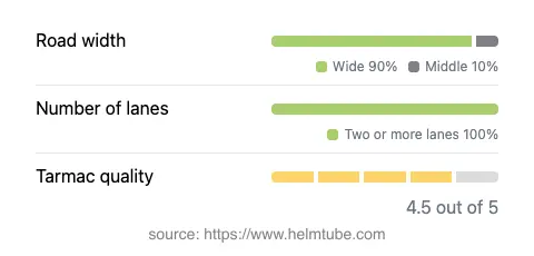
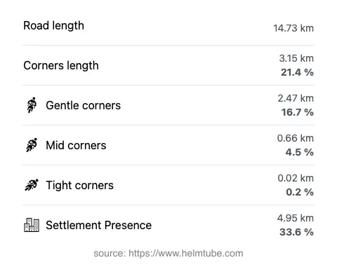
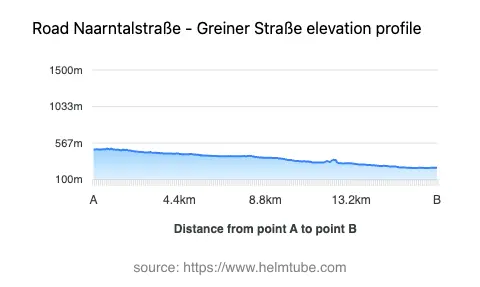
This route extends for approximately 14.7 km (9.1 miles), with the vast majority (about 90%) of the road classified as wide and two-laned (about 96%). The surface is asphalt and is generally rated as very good, offering a smooth and predictable ride. The road is gently curved, making it suitable for riders who prefer a less demanding journey. Elevation ranges from 249 m (817 ft) to 497 m (1,631 ft), providing mild elevation changes without steep gradients. The road passes through inhabited areas for roughly a third of its length, offering occasional glimpses of local life and amenities.
Riding Along the Naarn River
One of the defining features of the Naarntalstraße - Greiner Straße is its proximity to the Naarn River, with approximately 98% of the route running adjacent to the waterway. The Naarn is a tributary of the Danube and is known for its tranquil flow and natural surroundings. Riders will find the river a constant companion, with several opportunities to stop and enjoy the riverside environment. For more information about the river, visit the Naarn (river) page on Wikipedia.
Access, Closures, and Practical Considerations
The Naarntalstraße - Greiner Straße is open to motorcycles throughout the year, with no regular seasonal closures reported. There are no known restrictions specific to motorcycles, and the road remains accessible except in cases of temporary closures due to maintenance or local events. Riders are advised to check local traffic updates before planning their journey, especially during periods of adverse weather or community events that may affect access.
Tolls, Fees, and Additional Information
Currently, there are no tolls or entrance fees required to ride the Naarntalstraße - Greiner Straße. However, toll conditions may change in the future, and it is recommended to consult the official Austrian toll information page for the most up-to-date details: ASFINAG Toll Information. The road’s accessibility and lack of fees make it an attractive option for both local and visiting motorcyclists.
Nearby Attractions and Points of Interest
The town of Perg, located near the end of the route, offers a range of amenities and serves as a convenient base for exploring the region. Perg is known for its historical sites and local culture. For more information about Perg, see the Perg page on Wikipedia. The surrounding Naarntal valley is also notable for its rural charm and opportunities for outdoor activities, including hiking and cycling.
Explore the Region: Roads Close By
Discover more amazing roads located near the route featured in this article. The list below highlights nearby routes that are perfect for extending your ride or planning your next adventure.
Ride the Best: Austria’s Top Motorcycle Roads
These are the best motorbiking roads in Austria. The list below shows links to articles about top-rated motorcycle routes in the country. Explore the most popular roads in Austria and plan your next unforgettable motorbike adventure.