Exploring the Stoderstraße: A High Alpine Ride in the Dachstein Mountains
Locals know best!
If you travel this road often or live close by you will be given a chance to provide your valuable rating soon! Sign in and stay connected.Location and Access
The Stoderstraße is situated in the Austrian state of Styria, beginning near the village of Gröbming and ascending into the Dachstein mountain range. The road traverses the northern slopes of the Dachsteingebirge and Kemetgebirge, offering access to the Stoderzinken peak area. Its proximity to Gröbming makes it easily accessible from the Enns Valley, a region well-known among motorcyclists for its alpine routes. An interactive map showing the Stoderstraße can be found at the end of this article.
Road Characteristics and Riding Experience
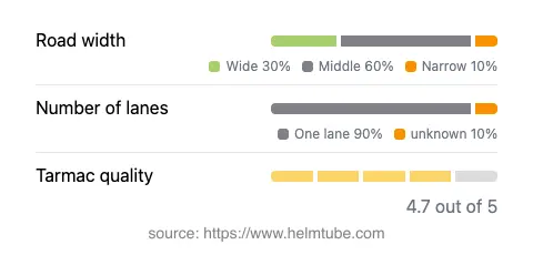
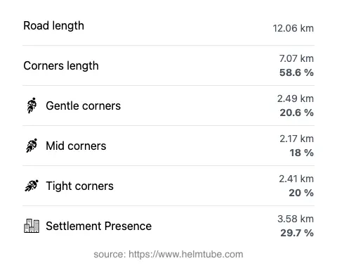
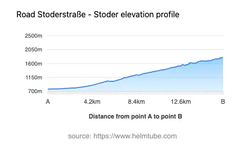
The Stoderstraße stretches for approximately 12.1 km (7.5 miles), climbing from an elevation of 772 m (2,533 ft) to 1,803 m (5,915 ft). The road is predominantly gently to moderately twisty, with several sections featuring sharper bends and hairpins as it ascends the mountain. The surface is asphalt and generally rated as very good, providing reliable grip for motorcycles. The route is mostly single-lane (about 90%), with the remainder offering slightly wider passing areas. The width varies, with the majority being of medium width (about 57%), and a significant portion classified as wide (32%). Riders should be prepared for narrow stretches, particularly in the upper sections. The road passes through a mix of forested and open alpine terrain, with approximately 30% of the route traversing inhabited or developed areas near the base.
Notable Attractions and Points of Interest
The Stoderstraße is best known for its access to the Stoderzinken peak, a prominent summit in the Dachstein region. At the upper terminus, visitors can explore hiking trails, alpine huts, and panoramic viewpoints overlooking the Enns Valley and the surrounding Alps. The road also provides views of the Dachstein Mountains, a UNESCO World Heritage Site recognized for its dramatic limestone formations. The area is popular for outdoor activities such as hiking, paragliding, and mountain biking, making it a versatile destination for motorcyclists seeking more than just a ride.
Road Closures and Seasonal Considerations
The Stoderstraße is a high alpine road and is typically closed to all traffic, including motorcycles, during the winter months due to snow and adverse weather conditions. The opening period generally extends from late spring to autumn, but exact dates can vary depending on snowfall and maintenance schedules. Riders are advised to check local information sources or the Gröbming tourism office for current road status before planning a trip. Occasional closures may also occur for maintenance or special events, particularly during the shoulder seasons.
Tolls, Fees, and Further Information
The Stoderstraße is a toll road, and motorcycles are required to pay an entrance fee to use the route. The fee is subject to change, and riders should consult the official Austrian tourism or road authority websites for the most up-to-date pricing. For more information about road tolls and entrance fees in Austria, visit the ASFINAG website. It is important to note that toll conditions may change in the future, and riders should verify details prior to travel.
Explore the Region: Roads Close By
Discover more amazing roads located near the route featured in this article. The list below highlights nearby routes that are perfect for extending your ride or planning your next adventure.
Ride the Best: Austria’s Top Motorcycle Roads
These are the best motorbiking roads in Austria. The list below shows links to articles about top-rated motorcycle routes in the country. Explore the most popular roads in Austria and plan your next unforgettable motorbike adventure.