Exploring the Kőszeg–Rechnitz Alpine Crossing: A Motorcyclist’s Guide
Locals know best!
If you travel this road often or live close by you will be given a chance to provide your valuable rating soon! Sign in and stay connected.Location and Geographic Context
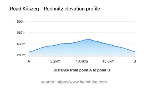
The Kőszeg–Rechnitz road connects the Austrian village of Rechnitz with the Hungarian town of Kőszeg, passing through a series of settlements including Pointgasse, Graben, Hauptplatz, Hauptstraße, Bahnhofstraße, Klostergasse, and Kirchengasse. The route is situated in the border region of Burgenland, Austria, and Vas County, Hungary, and traverses the Günser Gebirge (Kőszegi-hegység) mountain range, which forms part of the broader Randgebirge östlich der Mur and the Steirische Voralpen. The road’s elevation ranges from 327 m (1,073 ft) to 815 m (2,674 ft), offering a moderate ascent and descent profile. An interactive map showing the route is available at the end of this article.
Road Characteristics and Riding Experience
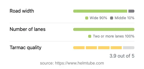
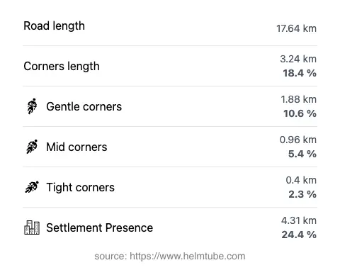
The Kőszeg–Rechnitz route extends for approximately 17.6 km (10.9 miles), with the majority of the road (about 91%) classified as wide and two-lane (about 96%). The surface is asphalt, with a quality rating that can be described as generally good, though not flawless. Riders can expect a moderately curvy experience, with the road offering a mix of gently winding sections and straighter stretches. The route passes through inhabited areas for roughly a quarter of its length, providing occasional access to local amenities. The maximum speed limits along the road are typically 50 km/h (31 mph) in settlements and up to 80 km/h (50 mph) in rural sections. The road’s profile and surface make it suitable for a range of motorcycles, from touring bikes to sportier models.
Tourist Attractions and Points of Interest
This cross-border route is notable for its proximity to several natural and cultural attractions. The Günser Gebirge, also known as the Kőszegi-hegység, is a low mountain range that forms part of the eastern Alps and is characterized by forested slopes and panoramic viewpoints. Riders will find opportunities to stop at designated viewpoints along the route, offering expansive views of the surrounding landscape. The town of Kőszeg is known for its well-preserved medieval center and historical fortifications, while Rechnitz offers access to hiking trails and local heritage sites. The road also intersects with the broader Alps region, providing a gateway to further exploration for those interested in alpine landscapes.
Seasonal Closures and Access Restrictions
There are currently no permanent closures for motorcycles on the Kőszeg–Rechnitz route. However, as with many alpine and subalpine roads in Austria, temporary closures may occur during winter months due to snow, ice, or maintenance work. Riders are advised to check local traffic updates before planning a trip, especially between November and March, when weather conditions can be unpredictable. No event-related closures have been reported for this route in recent years.
Tolls, Fees, and Practical Information
The Kőszeg–Rechnitz road does not currently require the payment of a toll or entrance fee for motorcycles. Riders should be aware that toll conditions may change in the future, and it is advisable to consult official resources for the most up-to-date information. For details on road tolls and vignettes in Austria, refer to the ASFINAG vignette information page. In Hungary, information on tolls can be found on the Hungarian e-vignette information site. No additional fees are required for accessing the viewpoints or natural attractions along this route.
Explore the Region: Roads Close By
Discover more amazing roads located near the route featured in this article. The list below highlights nearby routes that are perfect for extending your ride or planning your next adventure.
Ride the Best: Austria’s Top Motorcycle Roads
These are the best motorbiking roads in Austria. The list below shows links to articles about top-rated motorcycle routes in the country. Explore the most popular roads in Austria and plan your next unforgettable motorbike adventure.