Exploring the Pinkafeld–Unterhaus Alpine Route: A Motorcyclist’s Guide
Locals know best!
If you travel this road often or live close by you will be given a chance to provide your valuable rating soon! Sign in and stay connected.Location and Geographic Context
The Pinkafeld–Unterhaus route is situated in Austria, beginning near the town of Pinkafeld and concluding at the village of Unterhaus. The road passes through several settlements, including Hochneukirchenstraße, Hauptstraße, and Beim Höhwirt, and crosses the Randgebirge östlich der Mur and Steirische Voralpen mountain ranges, both part of the broader Alps. This region is characterized by rolling hills, forested slopes, and open vistas, offering a varied riding environment. An interactive map showing the route can be found at the end of the article.
Road Characteristics and Riding Experience
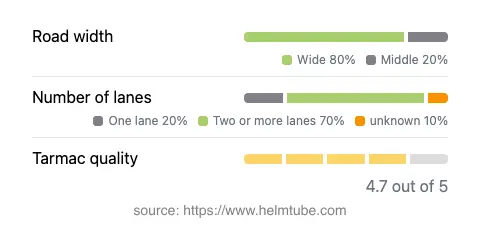
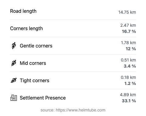
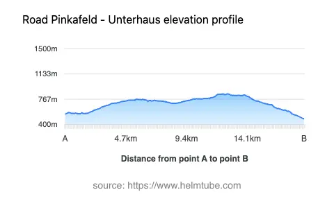
The Pinkafeld–Unterhaus Alpine Route extends for approximately 14.75 km (9.2 miles), with elevations ranging from 484 m (1,588 ft) to 845 m (2,772 ft). The road surface is asphalt and is generally of high quality, providing a smooth ride for most of its length. The route is gently curved, making it suitable for riders seeking a relaxed journey rather than a highly technical challenge. Most of the road is wide (about 75%), with two lanes for the majority of the distance (about 72%), while narrower sections are limited. The route passes through inhabited areas for roughly a third of its length, offering occasional opportunities to stop in local settlements.
Tourist Attractions and Points of Interest
One of the notable features of this route is its proximity to viewpoints that provide expansive views of the surrounding mountain landscape. The road’s passage through the Randgebirge östlich der Mur and the Steirische Voralpen offers riders the chance to experience the unique geography of the eastern Alps. While the area is less frequented by international tourists compared to other Alpine regions, it retains a distinct local character and offers a quieter alternative for those seeking to explore Austria’s mountainous terrain. The settlements along the route, such as Pinkafeld and Unterhaus, provide basic amenities and a glimpse into rural Austrian life.
Practical Information: Speed Limits, Closures, and Fees
Speed limits along the Pinkafeld–Unterhaus Alpine Route vary, with sections marked at 100 km/h (62 mph), 70 km/h (43 mph), and 50 km/h (31 mph), depending on proximity to settlements and road conditions. There are currently no known seasonal closures specific to motorcycles, and the road remains accessible throughout the year, though winter conditions may affect rideability due to snow or ice. No tolls or entrance fees are required to use this road. Riders should be aware that toll conditions may change in the future; for the most up-to-date information on road tolls and fees in Austria, consult the ASFINAG website.
Planning Your Ride and Additional Resources
When planning a ride along the Pinkafeld–Unterhaus Alpine Route, it is advisable to check local weather conditions, especially during winter months. The road’s gentle curves and high-quality surface make it accessible to riders of varying experience levels. For those interested in exploring the broader region, the proximity to the Alps provides opportunities for extended touring. An interactive map of the route is available below to assist with navigation and trip planning.
Explore the Region: Roads Close By
Discover more amazing roads located near the route featured in this article. The list below highlights nearby routes that are perfect for extending your ride or planning your next adventure.
Ride the Best: Austria’s Top Motorcycle Roads
These are the best motorbiking roads in Austria. The list below shows links to articles about top-rated motorcycle routes in the country. Explore the most popular roads in Austria and plan your next unforgettable motorbike adventure.