Exploring the Hochwolkersdorf–Stang Alpine Route: A Motorcyclist’s Guide
Locals know best!
If you travel this road often or live close by you will be given a chance to provide your valuable rating soon! Sign in and stay connected.Location and Setting
The Hochwolkersdorf–Stang route is situated in Lower Austria, beginning in the village of Hochwolkersdorf and concluding in the village of Stang. The road passes through several small settlements, including Wiesmather Straße, Wr. Neustädterstraße, Hauptstraße, Hauptplatz, and Spratzbach-Brücke. The route lies within the eastern fringes of the Alps, specifically crossing the Randgebirge östlich der Mur and the Steirische Voralpen. This region is known for its rolling hills, forested slopes, and traditional Austrian villages. An interactive map showing the road can be found at the end of the article.
Road Characteristics and Riding Experience
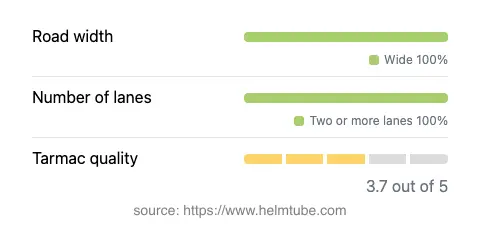
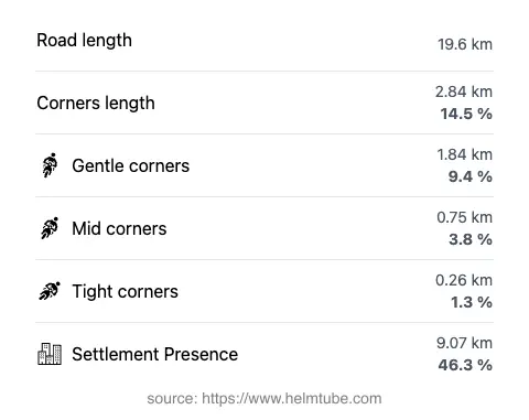
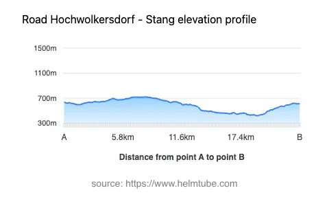
The Hochwolkersdorf–Stang Alpine Route covers approximately 19.6 km (12.2 miles), with elevations ranging from 422 m (1,385 ft) to 720 m (2,362 ft). The road surface is asphalt, offering a generally good riding experience, though the surface quality is best described as above average but not flawless. Riders will encounter a road that is gently curved, making it suitable for both experienced and less seasoned motorcyclists. The majority of the route (about 94%) is wide, with two lanes for most of its length (about 97%), ensuring comfortable passing and maneuvering. Nearly half of the road passes through inhabited areas, providing a mix of open countryside and village environments. The maximum speed limits along the route are 50 km/h (31 mph), 70 km/h (43 mph), and 100 km/h (62 mph), depending on the specific section.
Seasonal Closures and Accessibility
There are no permanent closures for motorcycles on the Hochwolkersdorf–Stang Alpine Route. The road remains accessible throughout the year, although winter conditions can affect drivability due to snow and ice, particularly at higher elevations. Temporary closures may occur during severe weather events or for road maintenance, but these are not specific to motorcycles. Riders are advised to check local traffic updates before planning their journey, especially in winter months. For up-to-date information on road conditions and closures in Austria, the ASFINAG Traffic Information website is a reliable resource.
Tolls, Fees, and Regulations
The Hochwolkersdorf–Stang Alpine Route does not currently require a toll or entrance fee for motorcycles. However, toll conditions in Austria may change, and it is advisable to verify the latest requirements before traveling. For comprehensive information on tolls and vignettes for Austrian roads, including updates on any changes, riders should consult the ASFINAG Toll and Vignette page. Standard Austrian traffic regulations apply, including adherence to posted speed limits and the use of appropriate safety gear.
Points of Interest and Attractions
While the route itself is primarily a connector between rural villages, it offers access to the broader attractions of the eastern Alps. The nearby Alps provide opportunities for hiking, sightseeing, and exploring traditional Austrian culture. The villages of Hochwolkersdorf and Stang are representative of the region’s rural heritage, with local inns and small-town architecture. Riders interested in extending their journey can explore the surrounding Steirische Voralpen, known for their gentle peaks and forested landscapes. For those seeking more information on the area, the Lonely Planet Lower Austria guide offers additional insights.
Explore the Region: Roads Close By
Discover more amazing roads located near the route featured in this article. The list below highlights nearby routes that are perfect for extending your ride or planning your next adventure.
Ride the Best: Austria’s Top Motorcycle Roads
These are the best motorbiking roads in Austria. The list below shows links to articles about top-rated motorcycle routes in the country. Explore the most popular roads in Austria and plan your next unforgettable motorbike adventure.