Motorcycling the Kreuzbergsattel: Exploring the Weißensee Straße in Austria
Locals know best!
If you travel this road often or live close by you will be given a chance to provide your valuable rating soon! Sign in and stay connected.Location and Setting of the Weißensee Straße
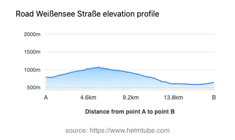
The Weißensee Straße is situated in the Austrian state of Carinthia, connecting the vicinity of Greifenburg with the region surrounding Lake Weißensee. The road crosses the Kreuzbergsattel, a mountain pass at an elevation of 1,074 m (3,524 ft), and passes through the Naturpark Weißensee. The route skirts the Kreuzeckgruppe and Gailtaler Alpen mountain ranges, offering access to the valleys of Oberes Drautal, Gitschtal, and Gnoppnitztal. The proximity to Greifenburg, a small town located less than 10 km (6.2 miles) from both ends of the road, makes it a convenient starting or ending point for riders. An interactive map showing the road can be found at the end of the article.
Road Details and Riding Experience
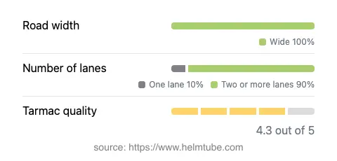
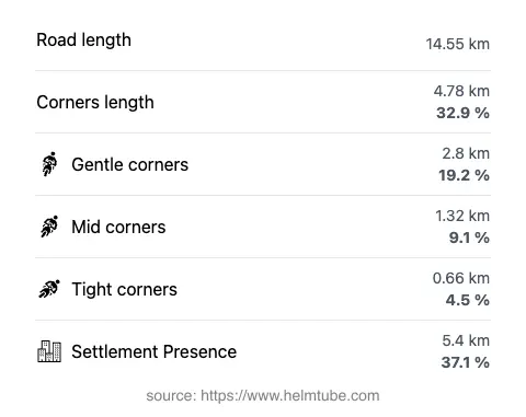
The Weißensee Straße extends for approximately 14.5 km (9 miles), with the majority of its length (about 90%) offering wide, two-lane asphalt. The surface quality is generally very good, providing a comfortable ride for most motorcycles. The road is moderately curvy, with a layout that alternates between gently curved sections and more pronounced bends, especially near the Kreuzbergsattel pass. Elevation ranges from 587 m (1,926 ft) at its lowest point to 1,076 m (3,530 ft) at its highest, ensuring a steady but manageable climb and descent. The route passes through inhabited areas for roughly a third of its length, while the remainder traverses forested and mountainous terrain. Speed limits are typically set at 70 km/h (43 mph) and 50 km/h (31 mph) in populated zones, reflecting the road’s mixed-use character.
Mountain Pass and Natural Attractions
The highlight of the Weißensee Straße is the Kreuzbergsattel, a mountain pass that serves as a gateway between the Drautal and Gitschtal valleys. The pass is well-known among local riders for its reliable road conditions and the panoramic viewpoints it offers. The road also passes through the Naturpark Weißensee, a protected area renowned for its clear alpine lake and diverse flora and fauna. Riders can enjoy views of the Weißensee itself, as well as glimpses of the Kreuzeckgruppe and Gailtaler Alpen. The valleys of Oberes Drautal and Gnoppnitztal are also accessible from the route, providing further opportunities for exploration.
Road Closures, Seasonal Access, and Regulations
The Weißensee Straße, including the Kreuzbergsattel, is generally open to motorcyclists throughout the year. However, due to its elevation and alpine setting, the pass may be temporarily closed during winter months or in adverse weather conditions such as heavy snowfall or ice. Riders are advised to check local traffic reports or the ASFINAG road conditions website before planning a trip, especially outside the main riding season. There are no known event-related closures affecting motorcycles, but occasional maintenance work may result in short-term restrictions.
Tolls, Fees, and Further Information
Currently, there is no toll or entrance fee required for motorcycles to use the Weißensee Straße or to cross the Kreuzbergsattel. Access to the Naturpark Weißensee is also free for through traffic, though parking fees may apply at designated lots near the lake. Riders should be aware that toll conditions may change in the future. For up-to-date information on road tolls and entrance fees in Austria, consult the official ASFINAG toll information page.
Explore the Region: Roads Close By
Discover more amazing roads located near the route featured in this article. The list below highlights nearby routes that are perfect for extending your ride or planning your next adventure.
Ride the Best: Austria’s Top Motorcycle Roads
These are the best motorbiking roads in Austria. The list below shows links to articles about top-rated motorcycle routes in the country. Explore the most popular roads in Austria and plan your next unforgettable motorbike adventure.