Exploring the Namlospass: The Reutte–Stanzach Mountain Pass Road
Locals know best!
If you travel this road often or live close by you will be given a chance to provide your valuable rating soon! Sign in and stay connected.Location and Setting of the Namlospass Road
The Reutte–Stanzach road, commonly referred to as the Namlospass, is situated in the Austrian state of Tyrol, within the Lechtal Alps. The route connects the town of Reutte to the village of Stanzach, passing through the settlements of Berwang and Gipfl. The road crosses several valleys, including the Rotlechtal, Lechtal, Namloser Tal, and Zwischentoren, and is set against the backdrop of the Lechtal Alps, a subrange of the Northern Limestone Alps. This region is characterized by rugged peaks and deep valleys, offering a distinctive alpine environment. An interactive map showing the road’s course can be found at the end of the article.
Road Characteristics and Riding Experience
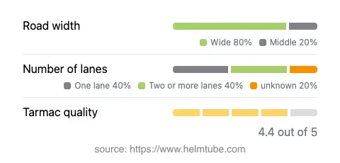
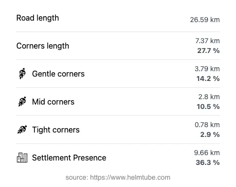
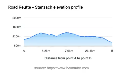
The Namlospass road extends for approximately 26.6 km (16.5 miles), with elevations ranging from 943 m (3,094 ft) at its lowest point to 1,372 m (4,501 ft) at its highest. The route is predominantly wide (about 79%), with the remainder being of medium width. The surface is asphalt and generally of high quality, providing a smooth riding experience. The road is moderately curvy, featuring a mix of gently curved and more technical sections, particularly as it ascends and descends the Namlospass at 1,359 m (4,459 ft). Riders will encounter both one-lane (about 40%) and two-lane (about 36%) segments, with the remainder varying in width. The road passes through inhabited areas for roughly a third of its length, offering occasional glimpses of local life amid the alpine scenery.
Mountain Pass and Valleys Along the Route
The highlight of this route is the Namlospass, a mountain pass that serves as a gateway between the Rotlechtal and Lechtal valleys. The pass is well-known among motorcyclists for its combination of elevation, curves, and panoramic views. The road also skirts the Namloser Tal and Zwischentoren valleys, each contributing to the varied topography and riding conditions. The Lechtal Alps, through which the road passes, are recognized for their limestone formations and are a popular destination for outdoor enthusiasts. For more information on the region, see the Lechtal Alps entry on Wikipedia.
Speed Limits, Seasonal Closures, and Practical Information
Speed limits along the Namlospass road vary, with posted limits of 40, 50, and 70 km/h (25, 31, and 43 mph) depending on the section. Riders should be attentive to local signage, as speed enforcement is common in Austria. The road is generally open to motorcycles throughout the year, but winter conditions can lead to temporary closures due to snow or ice, particularly at higher elevations. It is advisable to check local traffic reports or the ASFINAG road conditions website before planning a trip, especially outside the summer months. Event-related closures are rare but may occur during local festivals or road maintenance.
Tolls, Fees, and Additional Resources
Currently, there is no toll or entrance fee specifically for using the Namlospass road. However, toll conditions in Austria may change, and it is recommended to verify the latest information before traveling. For comprehensive details on road tolls and vignettes in Austria, consult the ASFINAG vignette information page. Riders should also be aware that some nearby highways and tunnels may require a separate toll sticker (vignette).
Explore the Region: Roads Close By
Discover more amazing roads located near the route featured in this article. The list below highlights nearby routes that are perfect for extending your ride or planning your next adventure.
Ride the Best: Austria’s Top Motorcycle Roads
These are the best motorbiking roads in Austria. The list below shows links to articles about top-rated motorcycle routes in the country. Explore the most popular roads in Austria and plan your next unforgettable motorbike adventure.