Exploring the Planseestraße: A Motorcycle Journey Through the Ammergau Alps
Locals know best!
If you travel this road often or live close by you will be given a chance to provide your valuable rating soon! Sign in and stay connected.Location and Setting of the Planseestraße
The Planseestraße is situated in the Tyrolean region of Austria, traversing the northern edge of the Alps. The road connects the vicinity of Reutte, a small town in Tyrol, with the Ammerwald area, running parallel to the picturesque Plansee lake. The route lies within the Ammergau Alps, a subrange of the Northern Limestone Alps, and is surrounded by alpine forests and rugged peaks. The proximity to the German border makes it a popular choice for riders coming from both Austria and southern Germany. An interactive map showing the full extent of the Planseestraße can be found at the end of this article.
Road Characteristics and Riding Experience
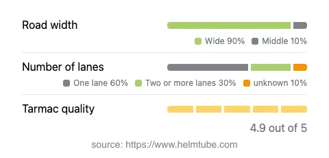
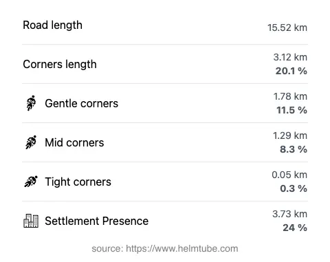
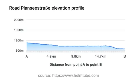
The Planseestraße stretches for approximately 15.5 km (9.6 miles), offering a gently curved ride with a moderate number of bends. The road surface is asphalt and is generally rated as excellent, providing a smooth and predictable riding experience. Most of the route is wide (about 90%), allowing for comfortable passage even when traffic is present. The road alternates between one and two lanes, with the majority being single-lane sections and a significant portion offering two lanes for easier overtaking. Elevation ranges from 870 m (2,854 ft) at its lowest point to 1,105 m (3,625 ft) at its highest, giving riders a sense of gradual ascent and descent through alpine terrain. The maximum speed limits vary along the route, with posted limits of 30, 50, 60, 70, and 100 km/h (19, 31, 37, 43, and 62 mph) depending on the section. About a quarter of the road passes through inhabited areas, but the majority runs through natural landscapes, making it a favored route for those seeking a tranquil ride.
Natural Attractions Along the Route
One of the defining features of the Planseestraße is its proximity to Plansee, a glacial lake renowned for its clear waters and alpine backdrop. The road hugs the shoreline for much of its length, providing frequent opportunities to stop and enjoy the views. There are several designated viewpoints along the route, offering panoramic vistas of both the lake and the surrounding mountains. The area is also part of the Ammergau Alps, which are known for their hiking trails, wildlife, and natural beauty. Riders may also encounter the smaller Heiterwanger See nearby, which is connected to Plansee by a short canal. These attractions make the Planseestraße not only a thoroughfare but also a destination for outdoor enthusiasts and photographers.
Seasonal Closures and Road Access
The Planseestraße is generally open to motorcyclists throughout the year, but weather conditions in the Alps can lead to temporary closures, especially during winter months due to snow and ice. It is advisable to check local traffic reports or the ASFINAG traffic reports before planning a trip, particularly in late autumn, winter, or early spring. There are no known event-related closures affecting motorcycles on a regular basis, but occasional maintenance or local events may result in short-term restrictions. Riders should remain alert for changing conditions, especially in the shoulder seasons.
Tolls, Fees, and Practical Information
Currently, there is no toll or entrance fee required to ride the Planseestraße. However, toll conditions in Austria are subject to change, and it is recommended to consult official sources for the most up-to-date information. For general information about road tolls and vignettes in Austria, riders can refer to the ASFINAG vignette information page. Parking fees may apply at certain lakeside stops or viewpoints, and these are typically posted on-site. As always, riders should ensure compliance with local regulations and be prepared for possible changes in access or fees.
Explore the Region: Roads Close By
Discover more amazing roads located near the route featured in this article. The list below highlights nearby routes that are perfect for extending your ride or planning your next adventure.
Ride the Best: Austria’s Top Motorcycle Roads
These are the best motorbiking roads in Austria. The list below shows links to articles about top-rated motorcycle routes in the country. Explore the most popular roads in Austria and plan your next unforgettable motorbike adventure.