Exploring the Niederthaier Straße: A Motorcyclist’s Guide through the Ötztal Alps
Locals know best!
If you travel this road often or live close by you will be given a chance to provide your valuable rating soon! Sign in and stay connected.Location and Access
Niederthaier Straße is situated in the Austrian state of Tyrol, running between the villages of Umhausen and Niederthai. The road ascends from the Ötztal valley, a region known for its dramatic alpine landscapes and traditional Tyrolean settlements. The Ötztal itself is a significant valley in western Austria, renowned for its outdoor recreation opportunities and proximity to the Alps. The route is easily accessible from the main Ötztal road, making it a convenient detour for riders exploring the broader Tyrolean region. An interactive map showing the Niederthaier Straße can be found at the end of the article.
Road Characteristics and Riding Experience
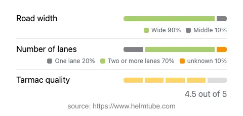
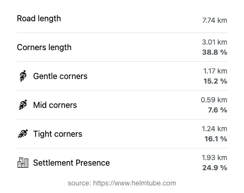
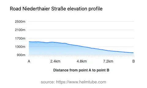
The Niederthaier Straße stretches for approximately 7.7 km (4.8 miles), with an elevation gain from 1,010 m (3,314 ft) to 1,541 m (5,056 ft). The road surface is asphalt and is generally of high quality, offering a smooth ride for most of its length. Riders will encounter a mix of gently curved and moderately twisty sections, making it suitable for both experienced and intermediate motorcyclists. The majority of the road is wide (about 90%), with the remainder being of medium width. Two-lane segments dominate (about 70%), while single-lane stretches are less common. The maximum speed limit is 60 km/h (37 mph), reflecting the road’s mountain character and the presence of occasional sharp bends. The route passes through both inhabited and uninhabited areas, with roughly a quarter of its length traversing village environments.
Alpine Setting and Points of Interest
Niederthaier Straße runs through the Ötztal valley, with sections also adjacent to the Horlachtal. The Ötztal is a well-known destination for outdoor enthusiasts, offering hiking, climbing, and winter sports. The road itself is part of the greater Alps, specifically intersecting with the Nördliche Stubaier Alpen, Larstiger Berge, Schrankogelgruppe, and Bachfallen-Larstig-Gruppe mountain ranges. Along the route, riders will find viewpoints that provide expansive views of the surrounding peaks and valleys. The villages of Niederthai and Umhausen serve as gateways to the region’s natural attractions, including the nearby Ötztal valley and the Stuibenfall, the highest waterfall in Tyrol.
Seasonal Closures and Road Regulations
Niederthaier Straße is subject to seasonal closures, particularly during winter months when snow and ice can make the route impassable. Motorcyclists are advised to check local traffic updates or the ASFINAG traffic reports before planning a ride, especially outside the main summer season. There are no known restrictions specifically for motorcycles, but standard Austrian road regulations apply, including adherence to posted speed limits and the use of appropriate safety gear.
Tolls, Fees, and Practical Information
Currently, there is no toll or entrance fee required to ride the Niederthaier Straße. However, toll conditions in Austria may change, and riders should verify the latest information before their trip. For up-to-date details on road tolls and vignettes in Austria, consult the official ASFINAG toll information page. Fuel and basic services are available in the nearby villages, but facilities along the road itself are limited. Riders are encouraged to plan accordingly, especially when traveling outside peak tourist periods.
Explore the Region: Roads Close By
Discover more amazing roads located near the route featured in this article. The list below highlights nearby routes that are perfect for extending your ride or planning your next adventure.
Ride the Best: Austria’s Top Motorcycle Roads
These are the best motorbiking roads in Austria. The list below shows links to articles about top-rated motorcycle routes in the country. Explore the most popular roads in Austria and plan your next unforgettable motorbike adventure.