Exploring the Längenfeld–Gries Alpine Road: A Motorcyclist’s Guide
Locals know best!
If you travel this road often or live close by you will be given a chance to provide your valuable rating soon! Sign in and stay connected.Location and Setting of the Längenfeld–Gries Road
The Längenfeld–Gries road is situated in the Austrian state of Tyrol, connecting the village of Längenfeld with the alpine settlement of Gries. The route follows the Sulztal valley, a side valley branching from the Ötztal, and is surrounded by the imposing peaks of the Stubaier Alps. The road’s location places it within a region known for its mountain scenery and outdoor activities, with the Sulztal valley forming a natural corridor between the two villages. An interactive map showing the route can be found at the end of this article.
Road Characteristics and Riding Experience
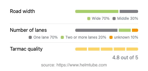
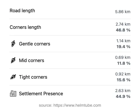
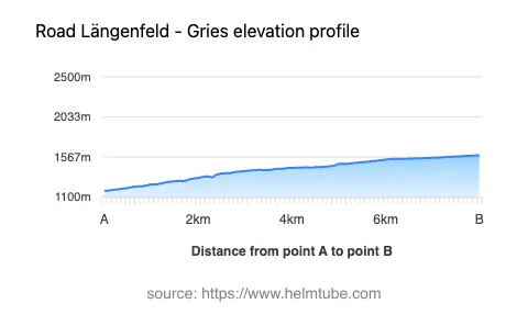
The Längenfeld–Gries road, locally referred to as Grieser Straße, covers a distance of approximately 5.9 km (3.7 miles). The route is predominantly wide (about 73%), with the remainder being of medium width. The surface is asphalt and is generally of excellent quality, providing a smooth ride for most motorcycles. The road is moderately twisty, offering a series of gentle to moderately sharp bends that require attentive riding but do not present extreme technical challenges. The elevation ranges from 1,176 m (3,858 ft) at Längenfeld to 1,587 m (5,207 ft) at Gries, resulting in a steady climb through the valley. The maximum speed limit is 30 km/h (19 mph), reflecting the road’s alpine character and the presence of inhabited areas along nearly half of its length. The route passes through both open alpine landscapes and sections adjacent to settlements, making it suitable for riders who appreciate a mix of natural and village environments.
Alpine Environment and Points of Interest
The road’s setting within the Alps and the Sulztal valley provides access to a range of outdoor attractions. The Sulztal valley itself is a notable destination for hiking and mountain sports, with Gries serving as a base for excursions into the surrounding peaks. The area is also part of the Nördliche Stubaier Alpen, Schrankogelgruppe, Bachfallen-Larstig-Gruppe, and Larstiger Berge mountain groups, which are popular among mountaineers and nature enthusiasts. While the road does not pass directly through major tourist attractions, its proximity to the village of Längenfeld offers access to the Aqua Dome thermal spa, a well-known wellness destination in the region. The combination of alpine scenery and recreational opportunities makes this road a worthwhile addition to any motorcycling itinerary in Tyrol.
Seasonal Accessibility and Road Regulations
The Längenfeld–Gries road is generally open to motorcyclists throughout the year, but winter conditions can lead to temporary closures due to snow and ice, particularly at higher elevations near Gries. Riders should check local advisories before planning a trip during the colder months. There are no permanent restrictions on motorcycle access, and the road is not subject to event-related closures under normal circumstances. However, weather-related disruptions are possible, especially in late autumn and winter.
Tolls, Fees, and Practical Information
Currently, there are no tolls or entrance fees required to use the Längenfeld–Gries road. Riders should be aware that toll conditions may change in the future, and it is advisable to consult official resources for the most up-to-date information. For details on road tolls and fees in Austria, refer to the ASFINAG toll information website. The road’s excellent surface quality and moderate traffic levels make it accessible for a wide range of motorcycles, from touring bikes to smaller displacement machines. Facilities such as fuel stations and restaurants are available in Längenfeld, while Gries offers limited services due to its smaller size and alpine location.
Explore the Region: Roads Close By
Discover more amazing roads located near the route featured in this article. The list below highlights nearby routes that are perfect for extending your ride or planning your next adventure.
Ride the Best: Austria’s Top Motorcycle Roads
These are the best motorbiking roads in Austria. The list below shows links to articles about top-rated motorcycle routes in the country. Explore the most popular roads in Austria and plan your next unforgettable motorbike adventure.