Ötztal Glacier Road (Ötztaler Gletscherstraße): A Technical Overview for Motorcyclists
Locals know best!
If you travel this road often or live close by you will be given a chance to provide your valuable rating soon! Sign in and stay connected.Location and Geographic Context
The Ötztal Glacier Road (Ötztaler Gletscherstraße) is situated in the Austrian Alps, within the federal state of Tyrol. The route begins near the town of Sölden and extends towards the village of Vent, traversing the Venter Tal valley. The road runs parallel to the Venter Ache river for its entire length, providing a consistent alpine environment. The surrounding landscape is defined by several valleys, including the Venter Tal, Gurgler Tal, Rofental, and Ötztal, and the road skirts or crosses mountain ranges such as the Ramolkoglkamm, Rettenbachkamm, Venter Zentralkamm, and the broader Alps. An interactive map showing the precise route of the Ötztal Glacier Road can be found at the end of this article.
Road Characteristics and Riding Experience
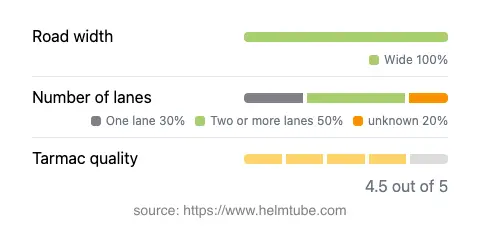
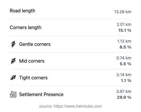
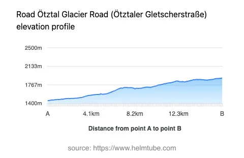
The Ötztal Glacier Road covers a distance of approximately 13.3 km (8.3 miles), with elevations ranging from 1,456 m (4,777 ft) to 1,901 m (6,237 ft). The road surface is asphalt and is generally of high quality, rated as excellent to very good. The route is moderately curvy, offering a mix of gently curved and more technical sections, but does not reach the extreme twistiness found on some alpine passes. The road width is predominantly wide (about 90%), with the remainder being of medium or narrow width. Most of the route consists of two lanes, with a smaller proportion featuring a single lane. The maximum speed limits vary along the road, with posted limits of 100 km/h (62 mph), 80 km/h (50 mph), and 30 km/h (19 mph) depending on the section. The road passes through inhabited areas for roughly 30% of its length, with the remainder traversing remote alpine terrain. The proximity to the Venter Ache river and the passage through multiple valleys contribute to the road’s alpine character.
Seasonal Accessibility and Closures
The Ötztal Glacier Road is subject to seasonal closures due to snow and adverse weather conditions typical of high-altitude alpine routes. The road is generally closed to all traffic, including motorcycles, during the winter months, typically from late autumn to spring. The exact dates of closure and reopening can vary annually depending on weather and maintenance schedules. There are no regular event-related closures reported, but temporary restrictions may occur due to local events or roadworks. Riders are advised to consult the official Tirol Road Condition Report for up-to-date information before planning a trip.
Tolls, Fees, and Regulations
The Ötztal Glacier Road is a public road and does not currently require a specific toll or entrance fee for motorcycles. However, toll conditions and regulations may change in the future, and it is recommended to verify the latest information prior to travel. For comprehensive details on tolls and road fees in Austria, including updates on the Ötztal Glacier Road, refer to the ASFINAG Toll Information website. Standard Austrian traffic regulations apply, including speed limits and safety requirements for motorcycles.
Nearby Settlements and Points of Interest
The nearest major settlement to the starting point of the Ötztal Glacier Road is the town of Sölden, located approximately 3.3 km (2 miles) from the road’s entrance. At the opposite end, the route concludes near the alpine village of Vent. The road’s alignment along the Venter Ache river and through the Venter Tal valley offers access to hiking trails and alpine vistas. The broader region is part of the Alps, a significant European mountain range known for its outdoor recreation opportunities (Alps). Motorcyclists may also be interested in exploring the nearby Gurgler Tal and Ötztal valleys, both of which are accessible from the main route and offer additional riding and sightseeing options.
Explore the Region: Roads Close By
Discover more amazing roads located near the route featured in this article. The list below highlights nearby routes that are perfect for extending your ride or planning your next adventure.
Ride the Best: Austria’s Top Motorcycle Roads
These are the best motorbiking roads in Austria. The list below shows links to articles about top-rated motorcycle routes in the country. Explore the most popular roads in Austria and plan your next unforgettable motorbike adventure.