Exploring the Ötztaler Gletscherstraße: Austria’s High Alpine Motorcycling Route
Locals know best!
If you travel this road often or live close by you will be given a chance to provide your valuable rating soon! Sign in and stay connected.Location and Setting of the Ötztaler Gletscherstraße
The Ötztaler Gletscherstraße is situated in the Tyrolean Alps of western Austria, beginning near the town of Sölden. The road ascends through the Ötztal and Rettenbachtal valleys, traversing the Rettenbachkamm subrange of the Alps. Its route provides access to the glacier ski areas above Sölden, making it a strategic link for both tourism and alpine exploration. The region is characterized by dramatic elevation changes, glacial landscapes, and panoramic mountain views. An interactive map showing the road’s course can be found at the end of this article.
Road Characteristics and Riding Experience
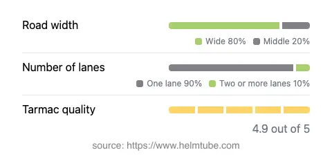
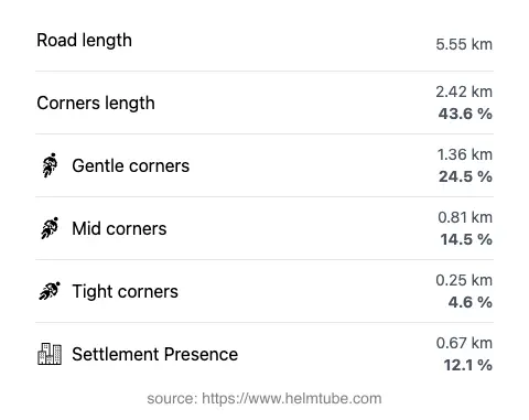
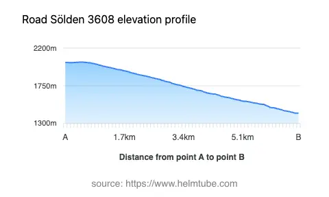
The Ötztaler Gletscherstraße extends for approximately 5.6 km (3.5 miles), with elevations ranging from 1,421 m (4,662 ft) at its lowest point to 2,032 m (6,667 ft) at its highest. The road surface is asphalt and is generally rated as excellent, providing a smooth and reliable riding experience. The route is moderately curvy, offering a mix of gently winding sections and more technical turns, which will appeal to riders who enjoy a balance between relaxed cruising and engaging cornering. Most of the road is wide (about 76%), with a smaller proportion being of medium width (24%). The majority of the route is single-lane (about 88%), with some sections offering two lanes (8%). The road passes through sparsely inhabited areas, with only about 12% of its length near settlements, ensuring a predominantly alpine environment. Speed limits vary along the route, typically ranging from 30 km/h (19 mph) in tighter sections to 100 km/h (62 mph) on straighter stretches, with intermediate limits of 50 km/h (31 mph) in certain areas.
Scenic Value and Notable Attractions
The Ötztaler Gletscherstraße is widely recognized as one of Austria’s most scenic alpine roads, offering expansive views of the surrounding peaks and glaciers. The route provides direct access to the Ötztal and Sölden glacier ski areas, which are popular destinations for both winter and summer visitors. The Rettenbachtal valley, traversed by the road, is notable for its rugged terrain and glacial features. Riders can also enjoy views of the Rettenbachkamm and the broader Alpine landscape. The road’s high elevation and proximity to glaciers make it a unique experience, especially during the summer months when snow remains visible on the peaks.
Seasonal Accessibility and Road Closures
The Ötztaler Gletscherstraße is subject to seasonal closures due to snow and adverse weather conditions, typically from late autumn through spring. The exact opening and closing dates vary depending on snowfall and maintenance schedules. Motorcyclists should check current road conditions before planning a trip, as temporary closures may also occur due to maintenance work or special events. The road is generally open to motorcycles during the accessible months, but restrictions may apply during periods of heavy snow or inclement weather. For up-to-date information on road status, consult the Tirol Road Conditions Report.
Tolls, Fees, and Practical Information
The Ötztaler Gletscherstraße is a toll road, and all vehicles, including motorcycles, are required to pay an entrance fee to access the glacier area. Toll rates are subject to change, and it is advisable to verify the current pricing before travel. Information on current tolls and payment methods can be found on the Austria.info Toll Information page. Riders should be prepared for rapidly changing weather conditions at high elevations and ensure their motorcycles are equipped for alpine riding. Facilities such as parking, rest areas, and restaurants are available near the glacier terminus, but services are limited along the ascent.
Explore the Region: Roads Close By
Discover more amazing roads located near the route featured in this article. The list below highlights nearby routes that are perfect for extending your ride or planning your next adventure.
Ride the Best: Austria’s Top Motorcycle Roads
These are the best motorbiking roads in Austria. The list below shows links to articles about top-rated motorcycle routes in the country. Explore the most popular roads in Austria and plan your next unforgettable motorbike adventure.