Exploring the Planaistraße: A Motorcyclist’s Guide to Austria’s Alpine Road
Locals know best!
If you travel this road often or live close by you will be given a chance to provide your valuable rating soon! Sign in and stay connected.Location and Setting of the Planaistraße
The Planaistraße is situated in the Austrian state of Styria, beginning and ending near the town of Schladming. The road traverses the Schladminger Tauern and Niedere Tauern mountain ranges, both subranges of the Eastern Alps. Its route passes through the Steirisches Ennstal valley, an area known for its alpine scenery and outdoor activities. The Planaistraße is particularly notable for its proximity to the Planai ski area and its role as an access road to various mountain viewpoints. An interactive map showing the route of the Planaistraße can be found at the end of this article.
Road Characteristics and Riding Experience
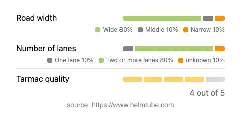
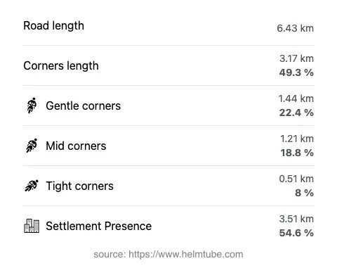
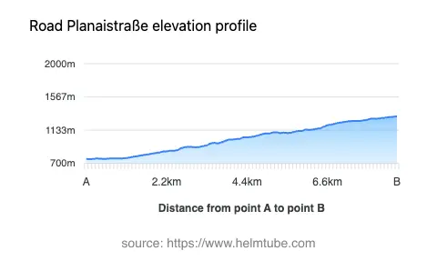
The Planaistraße extends for approximately 6.4 km (4 miles), with elevations ranging from 755 m (2,477 ft) at its lowest point to 1,314 m (4,311 ft) at its highest. The road surface is asphalt and is generally of high quality, rated as very good. Riders will encounter a mix of gently curved and moderately twisty sections, making it suitable for both experienced and intermediate motorcyclists. The majority of the road is wide (about 85%), with two lanes for most of its length (about 80%), allowing for comfortable passing and maneuvering. Only a small portion is single-lane or of medium width. The route passes through inhabited areas for just over half its length, providing a blend of alpine solitude and occasional village life. The road also runs adjacent to at least one notable viewpoint, offering opportunities for stops and photography.
Alpine Environment and Attractions
The Planaistraße is set within the broader context of the Schladminger Tauern and Niedere Tauern mountain ranges. These ranges are part of the Eastern Alps and are characterized by rugged peaks, alpine meadows, and forested slopes. The road’s proximity to the Steirisches Ennstal valley provides access to a region popular for hiking, skiing, and mountain biking. The Planai area, accessible via the Planaistraße, is a well-known ski destination and hosts international alpine skiing events. Motorcyclists can take advantage of several viewpoints along the route, offering expansive views of the surrounding mountains and valleys. The combination of natural beauty and recreational opportunities makes this road a notable destination for riders seeking an alpine experience.
Road Closures, Seasonal Access, and Practical Information
The Planaistraße is subject to seasonal closures, typically during the winter months due to snow and adverse weather conditions. Access for motorcycles is generally permitted during the open season, but riders should verify current conditions before planning a trip. Temporary closures may also occur due to maintenance work or special events, particularly during the ski season or for mountain sports competitions. For up-to-date information on road status, it is advisable to consult local tourism websites or the Austrian government road information portal.
Tolls, Fees, and Additional Considerations
The Planaistraße is a private toll road, and a fee is required for motor vehicles, including motorcycles, during the open season. Toll rates may vary depending on the time of year and vehicle type. Riders should be aware that toll conditions can change, and it is recommended to check the latest information before traveling. For current toll rates and regulations, refer to the ASFINAG toll information page. Additional services such as parking and access to mountain lifts may incur separate charges. Always ensure compliance with local traffic regulations and be prepared for rapidly changing weather conditions in the alpine environment.
Explore the Region: Roads Close By
Discover more amazing roads located near the route featured in this article. The list below highlights nearby routes that are perfect for extending your ride or planning your next adventure.
Ride the Best: Austria’s Top Motorcycle Roads
These are the best motorbiking roads in Austria. The list below shows links to articles about top-rated motorcycle routes in the country. Explore the most popular roads in Austria and plan your next unforgettable motorbike adventure.