Riding the Plöcken Pass: Kötschach to the Carnic Alps
Locals know best!
If you travel this road often or live close by you will be given a chance to provide your valuable rating soon! Sign in and stay connected.Location and Overview of the Plöcken Pass Road
The Plöcken Pass road, or Plöckenpass Straße (B110), is situated in the Oberkärnten area of Carinthia, Austria. It serves as a key alpine crossing between Austria and Italy, linking the town of Kötschach with the Passo di Monte Croce Carnico (Plöckenpass) at the border. The route is embedded within the Carnic Alps, a subrange of the greater Alps, and is recognized for its historical significance as well as its challenging terrain. The road’s proximity to the Italian region of Friuli-Venezia Giulia makes it a strategic connector for cross-border travel. An interactive map showing the route can be found at the end of this article.

Road Characteristics and Riding Experience
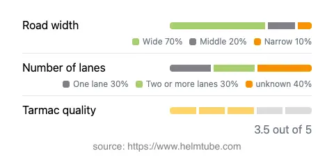
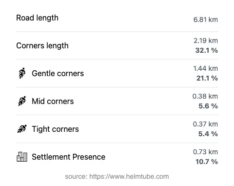
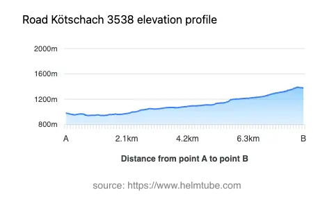
The Plöcken Pass road extends for approximately 6.8 km (4.2 miles) between Kötschach and the Austrian-Italian border. The route is predominantly surfaced with asphalt of moderate quality, offering a ride that is generally reliable but may present occasional rough patches. The road’s width varies, with the majority (about 70%) being wide enough for comfortable two-way traffic, while some sections narrow to single-lane passages, especially near the pass itself. The road is moderately twisty, featuring a mix of gently curved and sharper bends, particularly as it ascends toward the pass. Elevation ranges from 943 m (3,094 ft) at its lowest point to 1,389 m (4,557 ft) at its highest, with the Plöckenpass summit itself at 1,360 m (4,462 ft). The maximum speed limits are typically 70 km/h (43 mph) or 100 km/h (62 mph), depending on the section. The route passes through mostly uninhabited alpine terrain, with only about 11% of its length traversing settled areas. The road’s alignment through the Valle del But and its adjacency to the town of Kötschach make it a practical and engaging ride for motorcyclists.


Mountain Pass and Surrounding Attractions
The highlight of this route is the crossing of the Plöcken Pass (Passo di Monte Croce Carnico), a historic alpine pass with a long-standing role in trade and military history. The pass area features remnants of World War I fortifications and offers panoramic views of the Carnic Alps. Nearby, the town of Kötschach serves as a gateway to the region, providing access to local amenities and accommodations. The road also skirts the Valle del But, a lesser-known valley that marks the transition from Austria to Italy. For those interested in natural history, the Carnic Alps Geopark is accessible from Kötschach and offers insights into the region’s unique geology and biodiversity.
Road Closures, Seasonal Access, and Practical Information
The Plöcken Pass road is generally open to motorcycles throughout the year, but winter conditions can lead to temporary closures due to snow and ice, particularly at higher elevations. It is advisable to check current road status before planning a ride, as weather-related closures are common in the alpine months. There are no permanent restrictions for motorcycles, and the road is not subject to regular event-related closures. For up-to-date information on road conditions and seasonal closures, consult the ASFINAG Traffic Reports.
Tolls, Fees, and Additional Considerations
There is currently no toll or entrance fee required for motorcycles on the Plöcken Pass road. However, toll conditions may change in the future, and riders are encouraged to verify the latest information before traveling. For comprehensive details on tolls and fees applicable to Austrian roads, refer to the ASFINAG Toll Information page. Riders should also be aware of the variable road surface quality and the potential for rapidly changing weather conditions in the alpine environment. Proper preparation and attention to local regulations are recommended for a safe and enjoyable journey.
Explore the Region: Roads Close By
Discover more amazing roads located near the route featured in this article. The list below highlights nearby routes that are perfect for extending your ride or planning your next adventure.
Ride the Best: Austria’s Top Motorcycle Roads
These are the best motorbiking roads in Austria. The list below shows links to articles about top-rated motorcycle routes in the country. Explore the most popular roads in Austria and plan your next unforgettable motorbike adventure.