Exploring the Gailtal Straße: A Motorcyclist’s Guide Through Austria’s Alpine Valleys
Locals know best!
If you travel this road often or live close by you will be given a chance to provide your valuable rating soon! Sign in and stay connected.Location and Geographic Context
The Gailtal Straße (B111) is situated in the southern Austrian state of Carinthia, running predominantly through the Gail Valley. The route begins near the town of Kötschach and extends eastward, passing through a series of alpine villages before reaching Rodarm. The road closely follows the course of the Gail River for nearly half its length, offering riders views of the waterway as it winds toward its confluence with the Drau. The Gailtal Straße also intersects several valleys, including the Lesachtal, Tiroler Gailtal, and Raabtal, and crosses the Gailtaler Alpen and Lienzer Dolomiten mountain ranges. An interactive map showing the full extent of the Gailtal Straße can be found at the end of this article.
Road Characteristics and Riding Experience
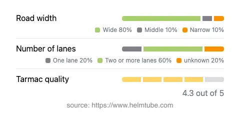
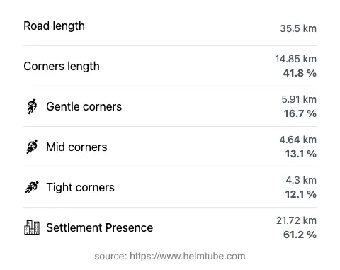
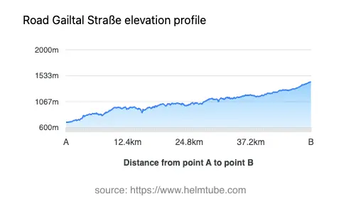
The Gailtal Straße extends for approximately 35.5 km (22.1 miles), with the majority of its surface composed of high-quality asphalt. Riders will find the road to be gently curved, making it suitable for both experienced and less seasoned motorcyclists. The route is predominantly wide (about 83%), with the remainder featuring medium and narrow sections. Most of the road consists of two lanes (about 61%), while single-lane stretches are less common. The elevation ranges from 697 m (2,287 ft) at its lowest point to 1,423 m (4,669 ft) at its highest, providing a moderate alpine riding experience without the extreme gradients found on some other mountain passes. The Gailtal Straße passes through inhabited areas for a significant portion of its length (about 61%), offering frequent opportunities for rest stops and refueling. The road’s proximity to the Gail River and its passage through the Lesachtal valley (about 79% of the route) contribute to its reputation as a favored route among touring motorcyclists.
Natural Features and Attractions Along the Route
One of the defining features of the Gailtal Straße is its alignment with the Gail River, a tributary of the Drau. The river’s presence is a constant companion for nearly half the journey, and riders can enjoy several viewpoints along the way. The road also traverses the Lesachtal, a valley renowned for its traditional alpine villages and unspoiled landscapes. The surrounding mountain ranges, including the Gailtal Alps and the Lienzer Dolomiten, provide a dramatic backdrop throughout the ride. Notable settlements along the route include Kötschach at the western end and Rodarm at the eastern terminus. Riders interested in local culture and history may wish to explore the villages of the Lesachtal, which are known for their preserved architecture and alpine traditions. For more information about the region, the Oberkärnten area offers additional insights into the broader geographic context.
Practical Considerations: Closures, Tolls, and Regulations
The Gailtal Straße is generally open to motorcyclists throughout the year, although temporary closures may occur due to adverse weather conditions, particularly in winter months when snow or ice can make certain sections hazardous. There are no permanent restrictions on motorcycle access. As of the latest available information, there is no toll or entrance fee required to use the Gailtal Straße. However, toll conditions may change in the future, and riders are advised to consult the official Austrian motorway and toll information page at ASFINAG for the most current details. Speed limits along the route vary, with posted limits of 50 km/h (31 mph), 60 km/h (37 mph), 80 km/h (50 mph), and 100 km/h (62 mph) depending on the section and proximity to settlements. Riders should remain attentive to local signage and adjust their speed accordingly, especially when passing through inhabited areas or during inclement weather.
Planning Your Ride and Additional Resources
When planning a motorcycle journey along the Gailtal Straße, it is advisable to check local weather forecasts and road conditions, particularly during the winter and early spring. The road’s high-quality surface and moderate curves make it accessible to a wide range of riders, but caution is recommended in narrower sections and near the river. The abundance of villages and viewpoints along the route provides ample opportunities for breaks and sightseeing. For those interested in extending their journey, the Gailtal Straße connects with other notable alpine routes in Carinthia and neighboring regions. Additional information about the Gail River can be found on its Wikipedia page, and details about the Lesachtal valley are available on Wikipedia. An interactive map of the Gailtal Straße is provided below to assist with route planning.
Explore the Region: Roads Close By
Discover more amazing roads located near the route featured in this article. The list below highlights nearby routes that are perfect for extending your ride or planning your next adventure.
Ride the Best: Austria’s Top Motorcycle Roads
These are the best motorbiking roads in Austria. The list below shows links to articles about top-rated motorcycle routes in the country. Explore the most popular roads in Austria and plan your next unforgettable motorbike adventure.