Exploring the Prekowa Pass Road: A Motorcyclist’s Guide to Austria’s Gurktal Alps
Locals know best!
If you travel this road often or live close by you will be given a chance to provide your valuable rating soon! Sign in and stay connected.Location and Access
The Prekowa Pass Road is situated in the Austrian state of Carinthia, running through the Gurktal Alps. The route connects the settlements of Prekowa-Straße, Feistritz, Badstraße, and Marktplatz, with the town of Straßburg serving as both the nearest starting and ending point. The road’s position within the Gurktal Alps places it amidst a region known for its mountainous terrain and traditional alpine villages. Riders can expect to encounter a mix of rural and mountainous environments, with the Metnitztal valley forming part of the landscape. An interactive map showing the full route of the Prekowa Pass Road can be found at the end of this article.
Road Characteristics and Riding Experience
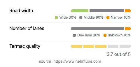
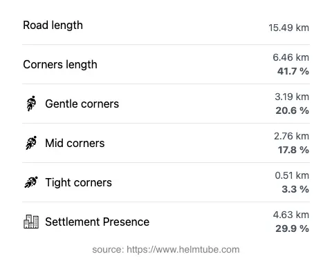
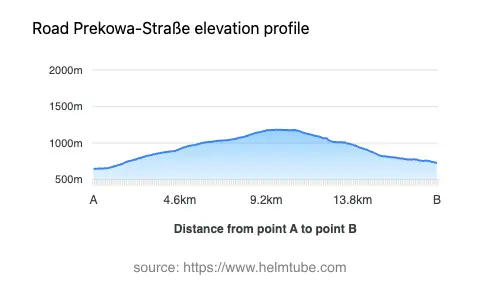
The Prekowa Pass Road extends for approximately 15.5 km (9.6 miles), offering a moderately twisty ride that will appeal to motorcyclists who enjoy technical, but not extreme, curves. The road surface is asphalt, with a surface quality rated as average to good. Riders will encounter a variety of road widths, with the majority (about 53%) being of medium width, and a significant portion (about 32%) classified as wide. Narrow sections are limited (about 8%), but caution is advised, especially in these areas. The road is predominantly single-lane (about 89%), which requires attentive riding, particularly when navigating through inhabited areas, which make up nearly 30% of the route. Elevation changes are notable, with the lowest point at 647 m (2,123 ft) and the highest at 1,183 m (3,881 ft), culminating at the Prekowa mountain pass at 1,288 m (4,226 ft). The route’s passage through the Metnitztal valley and the Gurktal Alps provides a varied riding environment, combining open alpine stretches with sections passing through small settlements.
Mountain Pass and Surrounding Attractions
The highlight of this route is the Prekowa mountain pass, which reaches an elevation of 1,288 m (4,226 ft). This pass is a lesser-known crossing within the Gurktal Alps, offering riders a quieter alternative to Austria’s more famous alpine roads. The Gurktal Alps themselves are a subrange of the Central Eastern Alps, known for their rolling hills and forested slopes. Nearby, the town of Straßburg is notable for its historic Straßburg Castle, a medieval fortress that dominates the local skyline. The Metnitztal valley, though only briefly intersected by the road, is recognized for its traditional rural character and scenic landscapes. For those interested in exploring further, the broader region offers access to the Gurktal Alps and the greater Alps, both of which are popular among outdoor enthusiasts.
Road Closures and Seasonal Considerations
The Prekowa Pass Road is generally open to motorcyclists throughout the year. However, as with many alpine routes in Austria, winter conditions can lead to temporary closures due to snow, ice, or maintenance work. Riders are advised to check local traffic information before planning a trip, especially during the colder months. There are no known permanent restrictions for motorcycles on this route. Event-related closures are rare but may occur in the case of local festivals or roadworks. For up-to-date information on road conditions and closures, consult the official ASFINAG Traffic Information service.
Tolls, Fees, and Practical Information
Currently, there are no tolls or entrance fees specifically for using the Prekowa Pass Road. However, toll conditions in Austria may change, and riders should verify the latest requirements before departure. For general information on road tolls and vignettes in Austria, including updates on pricing and regulations, visit the ASFINAG Toll and Vignette page. It is important to note that while this road does not require a special toll, the use of certain Austrian highways and expressways does require a valid vignette.
Explore the Region: Roads Close By
Discover more amazing roads located near the route featured in this article. The list below highlights nearby routes that are perfect for extending your ride or planning your next adventure.
Ride the Best: Austria’s Top Motorcycle Roads
These are the best motorbiking roads in Austria. The list below shows links to articles about top-rated motorcycle routes in the country. Explore the most popular roads in Austria and plan your next unforgettable motorbike adventure.