Exploring the Sankt Veit an der Glan – Gurk Route: A Motorcyclist’s Guide through the Gurktal Alps
Locals know best!
If you travel this road often or live close by you will be given a chance to provide your valuable rating soon! Sign in and stay connected.Location and Overview of the Sankt Veit an der Glan – Gurk Route
The Sankt Veit an der Glan – Gurk route is situated in the Austrian state of Carinthia, running between the towns of Sankt Veit an der Glan and Gurk. The road crosses the Gurktal Alps, a subrange of the Central Eastern Alps, and passes through a series of small settlements including Wimitzer Straße, Zensweger Straße, Kraiger-See-Straße, Landesstraße, Grabenstraße, Waagstraße, and Spitalgasse. The route is positioned in a region known for its alpine scenery and proximity to the Gurk River, which it briefly parallels. An interactive map showing the exact course of the road can be found at the end of this article.
Road Characteristics and Riding Experience
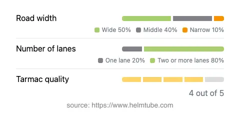
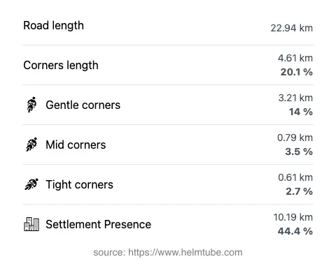
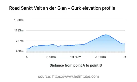
This road extends for approximately 22.9 km (14.2 miles), offering a moderately curvy ride suitable for a range of motorcycling skill levels. The surface is asphalt and is generally rated as very good, with most sections providing a smooth and predictable ride. The majority of the route consists of two-lane stretches (about 76%), with the remainder being single-lane or wider sections. Road width is predominantly wide (about 50%), with middle-width segments making up a significant portion as well. The elevation ranges from 483 m (1,585 ft) at its lowest point to 983 m (3,225 ft) at its highest, providing moderate altitude changes without extreme gradients. Speed limits vary along the route, with posted limits of 30, 50, and 70 km/h (19, 31, and 43 mph) depending on the section and proximity to inhabited areas.
Natural Features and Points of Interest
The route briefly follows the Gurk River, a notable waterway in Carinthia that eventually joins the Drau. While only a small portion of the road runs adjacent to the river, the presence of water and the surrounding alpine landscape contribute to the overall riding experience. The road also traverses the Gurktal Alps, a region characterized by rolling hills, forested slopes, and traditional Austrian villages. Notable nearby attractions include the Gurk Cathedral in Gurk, a significant Romanesque church, and the historic town center of Sankt Veit an der Glan. These sites offer opportunities for cultural exploration in addition to the motorcycling experience.
Road Closures, Seasonal Considerations, and Regulations
There are no known permanent closures for motorcycles on this route. However, as with many alpine roads in Austria, temporary closures may occur due to weather conditions, particularly during winter months when snow and ice can make travel hazardous. Riders are advised to check local traffic updates before departure. There are no regular event-related closures reported for this road. For up-to-date information on road conditions and closures, the ASFINAG Traffic Reports website provides current details for Austrian roads.
Tolls, Fees, and Practical Information
This route does not currently require a toll or entrance fee for motorcycles. Riders should be aware that toll conditions in Austria may change, and it is advisable to consult official sources before planning a trip. For comprehensive information on tolls and vignette requirements for Austrian roads, refer to the ASFINAG Toll and Vignette page. Fuel stations and basic amenities are available in both Sankt Veit an der Glan and Gurk, but options may be limited along the rural stretches of the route.
Explore the Region: Roads Close By
Discover more amazing roads located near the route featured in this article. The list below highlights nearby routes that are perfect for extending your ride or planning your next adventure.
Ride the Best: Austria’s Top Motorcycle Roads
These are the best motorbiking roads in Austria. The list below shows links to articles about top-rated motorcycle routes in the country. Explore the most popular roads in Austria and plan your next unforgettable motorbike adventure.