Riding the Pyhrn Pass: Spital am Pyhrn to Liezen
Locals know best!
If you travel this road often or live close by you will be given a chance to provide your valuable rating soon! Sign in and stay connected.Location and Overview
The Spital am Pyhrn – Liezen road is situated in the Austrian state of Styria, connecting the village of Spital am Pyhrn to the town of Liezen. The route follows the Pyhrnpass Straße (B138), a key north-south corridor through the Ennstaler Alps. The road serves as a traditional alpine crossing, linking the southern and northern regions of the Alps. The area is characterized by mountainous terrain, with the road passing through both inhabited valleys and higher elevation passes. An interactive map showing the route is available at the end of the article.
Road Characteristics and Riding Experience
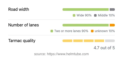
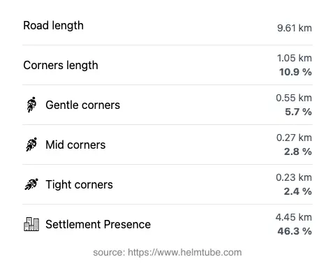
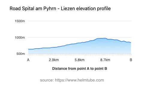
This section of the Pyhrnpass Straße covers approximately 9.6 km (6 miles), with elevations ranging from 640 m (2,100 ft) to 976 m (3,202 ft). The road is predominantly wide (about 90%), with two lanes for most of its length, providing ample space for overtaking and maneuvering. The surface is asphalt and generally rated as very good, offering a smooth ride. The route is moderately curved, with gentle bends rather than sharp switchbacks, making it accessible for riders of varying skill levels. The maximum speed limits are 50 km/h (31 mph) in inhabited areas and up to 100 km/h (62 mph) in open sections. The road passes through both rural and urbanized areas, with nearly half of its length adjacent to settlements. The Pyhrn Pass itself, at 954 m (3,130 ft), is the highest point, offering views of the surrounding Ennstaler Alps.
Natural Features and Points of Interest
The route crosses the Ennstaler Alps, a subrange of the Northern Limestone Alps, and briefly follows the Teichl River for about 20% of its length. The Teichl is a tributary of the Steyr and adds a natural element to the ride, with occasional glimpses of the river valley. The Pyhrn Pass is a historic alpine crossing, and the surrounding region is known for its hiking trails and alpine scenery. The starting point, Spital am Pyhrn, is a traditional alpine village, while Liezen serves as a regional hub with access to further routes into the Austrian Alps. The Ennstaler Alps themselves are recognized for their rugged limestone peaks and are a destination for outdoor enthusiasts.
Road Closures and Seasonal Considerations
The Pyhrn Pass road is generally open year-round, but temporary closures can occur during periods of heavy snowfall or adverse weather, particularly in winter months. Motorcyclists should be aware that alpine weather conditions can change rapidly, and it is advisable to check local traffic reports before departure. There are no permanent restrictions for motorcycles on this section of the road. Event-related closures are rare but may occur during local festivals or road maintenance operations.
Tolls, Fees, and Practical Information
There is currently no toll or entrance fee required for motorcycles on the Pyhrn Pass road between Spital am Pyhrn and Liezen. However, toll conditions may change in the future, and riders are encouraged to verify the latest information before traveling. For up-to-date details on road tolls and fees in Austria, consult the official ASFINAG toll information website. Fuel stations and basic amenities are available in both Spital am Pyhrn and Liezen, making this route suitable for day trips or as part of a longer alpine tour.
Explore the Region: Roads Close By
Discover more amazing roads located near the route featured in this article. The list below highlights nearby routes that are perfect for extending your ride or planning your next adventure.
Ride the Best: Austria’s Top Motorcycle Roads
These are the best motorbiking roads in Austria. The list below shows links to articles about top-rated motorcycle routes in the country. Explore the most popular roads in Austria and plan your next unforgettable motorbike adventure.