Exploring the Radstatthöhe Pass: B 25 Erlauftal Straße in Austria
Locals know best!
If you travel this road often or live close by you will be given a chance to provide your valuable rating soon! Sign in and stay connected.Location and Geographic Context
The B 25 Erlauftal Straße is situated in Austria, running through the state of Styria (Steiermark) and forming a vital connection across the Radstatthöhe mountain pass. The road is positioned within the northern sector of the Austrian Alps, intersecting the Hochschwab-Gruppe and skirting both the Ybbstaler Alpen and Ennstaler Alpen. The route follows the Salza river for a significant portion, providing a corridor through the Steirisches Ennstal valley. The surrounding landscape is characterized by alpine forests, river valleys, and mountainous terrain. An interactive map showing the precise route of the B 25 Erlauftal Straße can be found at the end of this article.
Road Characteristics and Riding Experience
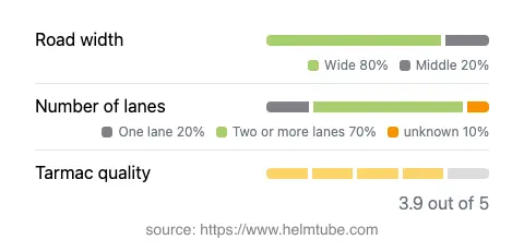
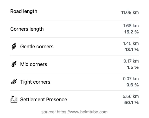
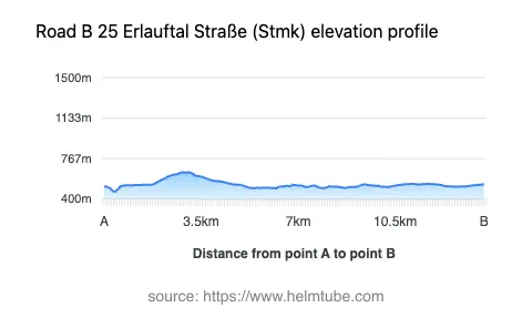
The B 25 Erlauftal Straße extends for approximately 11.1 km (6.9 miles), with elevations ranging from 468 m (1,535 ft) to 643 m (2,110 ft) at its highest point on the Radstatthöhe pass. The road surface is asphalt, with a generally good quality rating, though some sections may show moderate wear. The route is moderately curvy, offering a mix of gently curved and straight segments, making it suitable for riders seeking a balanced experience rather than extreme twistiness. Road width varies, with the majority (about 70%) being wide enough for comfortable two-way traffic, while narrower sections are less common. Two-lane stretches dominate (about 66%), with some single-lane portions, especially near the pass. The road passes through both inhabited and remote areas, with roughly half its length adjacent to settlements. The proximity to the Salza river (about 43% of the route) adds to the riding atmosphere, as does the brief passage through the Steirisches Ennstal valley. The maximum speed limits are 100 km/h (62 mph), 70 km/h (43 mph), and 50 km/h (31 mph), depending on the section.
Mountain Pass and Natural Features
The highlight of the B 25 Erlauftal Straße is its crossing of the Radstatthöhe pass, which reaches an elevation of 637 m (2,090 ft). This pass is a notable feature for motorcyclists, offering panoramic views of the surrounding Hochschwab Group and access to the broader Alps. The road also skirts the Ybbstal Alps and Ennstal Alps, providing varied alpine scenery. The Salza river, a tributary of the Enns, runs alongside the road for much of its length, offering opportunities for brief stops and riverside views. The Steirisches Ennstal valley, though only briefly adjacent to the route, adds to the diversity of landscapes encountered along the way.
Road Closures, Seasonal Access, and Practical Considerations
The B 25 Erlauftal Straße, including the Radstatthöhe pass, is generally open year-round. However, temporary closures can occur due to adverse weather conditions, particularly in winter months when snow and ice may make the pass hazardous. There are no permanent restrictions for motorcycles, but riders should check local traffic updates before departure, especially during the colder seasons. Event-related closures are rare but possible during road maintenance or local events. For up-to-date information on road conditions and closures, the ASFINAG Traffic Reports website provides current details.
Tolls, Fees, and Additional Information
There is currently no toll or entrance fee required to ride the B 25 Erlauftal Straße or cross the Radstatthöhe pass. However, toll conditions may change in the future, and it is advisable to verify the latest requirements before planning your trip. For comprehensive information on tolls and fees for Austrian roads, including updates and exceptions, consult the ASFINAG Toll Information page. Riders should also ensure their motorcycles comply with Austrian road regulations, including the use of headlights during the day and carrying appropriate safety equipment.
Explore the Region: Roads Close By
Discover more amazing roads located near the route featured in this article. The list below highlights nearby routes that are perfect for extending your ride or planning your next adventure.
Ride the Best: Austria’s Top Motorcycle Roads
These are the best motorbiking roads in Austria. The list below shows links to articles about top-rated motorcycle routes in the country. Explore the most popular roads in Austria and plan your next unforgettable motorbike adventure.