Riding the Ramssattel Pass: Gloggnitz to Ternitz
Locals know best!
If you travel this road often or live close by you will be given a chance to provide your valuable rating soon! Sign in and stay connected.Location and Access
The Ramssattel Pass Road connects the towns of Gloggnitz and Ternitz in Lower Austria, running through the eastern reaches of the Alps. The route begins near Gloggnitz, a town situated approximately 7.8 km (4.8 miles) from the starting point, and concludes near Ternitz, which lies about 2.9 km (1.8 miles) from the road's endpoint. The road crosses the Ramssattel mountain pass at an elevation of 824 m (2,703 ft), providing access through the Steirische Voralpen and the Randgebirge östlich der Mur. The area is characterized by a mix of inhabited valleys and forested mountain terrain, with the Raunzgraben valley forming part of the route. An interactive map showing the full extent of the Ramssattel Pass Road can be found at the end of this article.
Road Characteristics and Riding Experience
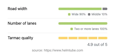
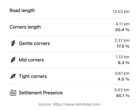
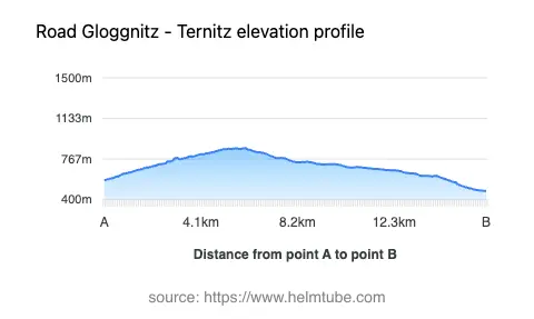
The Ramssattel Pass Road extends for approximately 13.5 km (8.4 miles), with the majority of its length (about 86%) classified as wide, two-lane asphalt. The surface quality is excellent, offering a smooth and predictable ride. The road is moderately curvy, providing a balance between straight sections and gently winding curves, making it suitable for riders of varying skill levels. About 40% of the route passes through inhabited areas, while the remainder traverses forested and mountainous terrain. The elevation ranges from 479 m (1,572 ft) at its lowest point to 865 m (2,838 ft) at its highest, with the Ramssattel Pass itself situated at 824 m (2,703 ft). The road runs adjacent to the Raunzgraben valley for a portion of its length and features at least one notable viewpoint, offering opportunities to pause and appreciate the surrounding landscape.
Mountain Pass and Surrounding Geography
The highlight of this route is the crossing of the Ramssattel Pass, a lesser-known but historically significant mountain pass in the region. The pass is part of the Alps and intersects with the Steirische Voralpen and the Randgebirge östlich der Mur. The surrounding area is characterized by dense forests, rolling hills, and occasional clearings that provide views across the valleys. The Raunzgraben valley, which the road skirts for a short distance, adds to the varied topography encountered along the ride. The route is not as heavily trafficked as some of the more famous alpine passes, making it an appealing option for those seeking a quieter ride through the Austrian mountains.
Speed Limits, Road Closures, and Seasonal Considerations
Speed limits along the Ramssattel Pass Road vary, with lower limits of 50 km/h (31 mph) in inhabited areas and higher limits of up to 100 km/h (62 mph) on open stretches. Riders should be attentive to posted signs, as limits may change depending on local conditions. The road is generally open year-round, but winter conditions can lead to temporary closures or hazardous surfaces due to snow and ice, particularly at higher elevations. There are no permanent restrictions on motorcycle access. However, it is advisable to check local traffic updates or the ASFINAG traffic information website for current road status, especially during the winter months or in the event of roadworks or special events.
Tolls, Fees, and Additional Information
There are currently no tolls or entrance fees required to ride the Ramssattel Pass Road. Riders should note that toll conditions may change in the future, and it is recommended to consult the ASFINAG toll information page for the most up-to-date details on tolls and vignettes for Austrian roads. The absence of tolls makes this route an accessible option for both local and visiting motorcyclists. For those interested in exploring the nearby towns, both Gloggnitz and Ternitz offer amenities and services suitable for travelers.
Explore the Region: Roads Close By
Discover more amazing roads located near the route featured in this article. The list below highlights nearby routes that are perfect for extending your ride or planning your next adventure.
Ride the Best: Austria’s Top Motorcycle Roads
These are the best motorbiking roads in Austria. The list below shows links to articles about top-rated motorcycle routes in the country. Explore the most popular roads in Austria and plan your next unforgettable motorbike adventure.