Exploring the Schloßbergerstraße: A Motorcyclist’s Guide Through the Austrian Alps
Locals know best!
If you travel this road often or live close by you will be given a chance to provide your valuable rating soon! Sign in and stay connected.Location and Overview of Schloßbergerstraße
Schloßbergerstraße is situated in southern Austria, running between the town of Ruše and the village of Leutschach an der Weinstraße. The road crosses several notable mountain ranges, including the Alps, Steirische Voralpen, Poßruck (also known as Kozjak), and the Lavanttal Alps. This region is characterized by its rolling hills, forested slopes, and vineyard-dotted valleys. The proximity to the Austrian-Slovenian border adds to the road’s appeal for riders seeking cross-border adventures. An interactive map showing the route of Schloßbergerstraße can be found at the end of this article.
Road Characteristics and Riding Experience
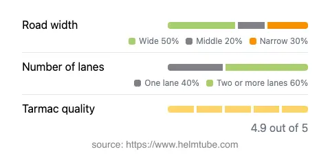
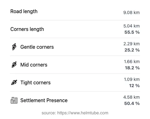
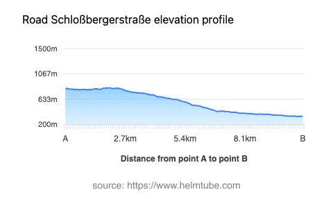
Schloßbergerstraße extends for approximately 9.1 km (5.7 miles), with an elevation range from 338 m (1,109 ft) to 831 m (2,726 ft). The road is predominantly surfaced with high-quality asphalt, offering a smooth and reliable riding experience. Riders will encounter a mix of gently curved and moderately twisty sections, making it suitable for both novice and experienced motorcyclists. The road width varies, with wide sections making up about 43% of the route, while the remainder alternates between narrow and middle-width stretches. Most of the road features two lanes (about 57%), with the rest being single-lane, particularly in more remote or mountainous segments. The maximum speed limit is 50 km/h (31 mph), reflecting the road’s passage through both inhabited and rural areas. Approximately half of the route traverses settlements, providing access to local amenities and services.
Mountain Ranges and Natural Attractions
One of the defining features of Schloßbergerstraße is its intersection with several mountain ranges. The route crosses the eastern foothills of the Alps, the Steirische Voralpen, the Poßruck (Kozjak), and the Lavanttal Alps. These ranges are known for their diverse flora and fauna, as well as panoramic views over the Styrian countryside. The area around Leutschach an der Weinstraße is particularly renowned for its vineyards and wine culture, making it a popular destination for gastronomic tourism. Riders may wish to explore local wineries or take short detours to enjoy the region’s culinary offerings. The proximity to the South Styria Wine Road further enhances the appeal for those interested in local culture and landscapes.
Road Closures, Seasonal Access, and Regulations
Schloßbergerstraße is generally open to motorcyclists throughout the year. However, as with many alpine roads, temporary closures may occur during periods of heavy snowfall or adverse weather, particularly in winter months. There are no permanent restrictions on motorcycle access. Riders are advised to check local traffic updates or the ASFINAG traffic reports for current road conditions and any event-related closures before planning their journey.
Tolls, Fees, and Further Information
Currently, there are no tolls or entrance fees required to ride the Schloßbergerstraße. However, toll conditions may change in the future, and riders should verify the latest information before departure. For comprehensive details on road tolls and fees in Austria, consult the ASFINAG toll information page. This resource provides up-to-date guidance on toll requirements for motorcycles and other vehicles across the country.
Explore the Region: Roads Close By
Discover more amazing roads located near the route featured in this article. The list below highlights nearby routes that are perfect for extending your ride or planning your next adventure.
Ride the Best: Austria’s Top Motorcycle Roads
These are the best motorbiking roads in Austria. The list below shows links to articles about top-rated motorcycle routes in the country. Explore the most popular roads in Austria and plan your next unforgettable motorbike adventure.