Exploring the St.-Lorenzen-Straße: A Motorcyclist’s Guide Through the Styrian Alps
Locals know best!
If you travel this road often or live close by you will be given a chance to provide your valuable rating soon! Sign in and stay connected.Location and Geographic Context
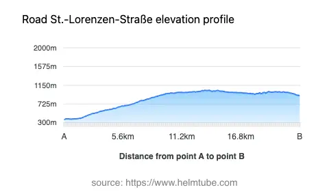
The St.-Lorenzen-Straße is situated in the southeastern part of Austria, within the federal state of Styria. The road passes through the settlement of St. Lorenzen and traverses the foothills and lower slopes of the Alps, specifically intersecting the Steirische Voralpen, Koralpe, and Lavanttaler Alpen. This region is characterized by a mix of forested hills, alpine meadows, and small rural communities. The route’s elevation ranges from 371 m (1,217 ft) at its lowest point to 1,036 m (3,399 ft) at its highest, providing moderate altitude changes typical of the Styrian Alps. An interactive map showing the precise route of the St.-Lorenzen-Straße can be found at the end of this article.
Road Characteristics and Riding Experience
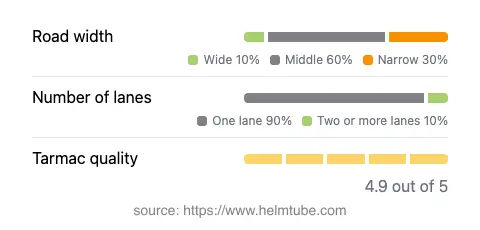
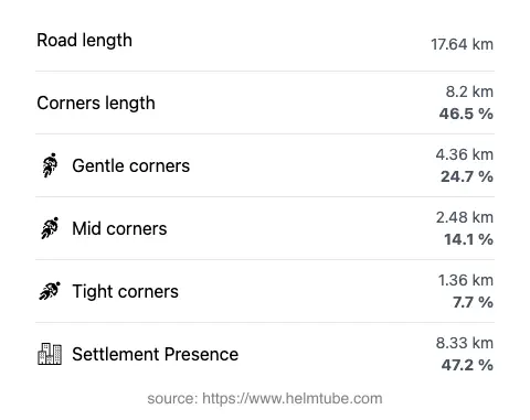
The St.-Lorenzen-Straße extends for approximately 17.6 km (10.9 miles), making it a manageable ride for a half-day excursion or as part of a longer tour through the region. The road surface is asphalt and is generally rated as excellent, with only minor imperfections. The route is moderately curvy, offering a mix of gently winding sections and occasional tighter bends, suitable for riders seeking a balance between relaxed touring and technical riding. Most of the road is of medium width (about 55%), with narrower stretches (30%) and some wider segments (12%). The majority of the route is single-lane (about 85%), with a small proportion offering two lanes (6%). Nearly half of the road passes through inhabited areas, providing opportunities to experience local Styrian culture and hospitality.
Mountain Ranges and Natural Features
This road is notable for crossing several distinct mountain ranges. The broader Alps form the backdrop, while the Koralpe and Lavanttaler Alpen provide more localized alpine scenery. The Steirische Voralpen, or Styrian Prealps, are also traversed, offering a landscape of rolling hills and forested slopes. While the road does not reach the dramatic heights of Austria’s most famous alpine passes, it provides a representative cross-section of the region’s geography and is well-suited for riders interested in exploring less-traveled routes through the Austrian Alps.
Practical Information: Closures, Tolls, and Regulations
There are currently no known seasonal closures specific to the St.-Lorenzen-Straße for motorcycles. However, as with many alpine roads in Austria, temporary closures may occur due to weather conditions, maintenance, or local events. Riders are advised to check local traffic information before departure. There is no toll or entrance fee required to use this road, but toll conditions in Austria may change in the future. For up-to-date information on road tolls and regulations, consult the official Austrian toll information portal at ASFINAG. The maximum speed limit on this road is 100 km/h (62 mph), though lower limits may apply in inhabited areas or on tighter curves.
Attractions and Points of Interest Along the Route
While the St.-Lorenzen-Straße itself is primarily a transit route through rural and alpine landscapes, the surrounding region offers several attractions for those interested in extending their journey. The nearby Koralpe mountain range is popular for hiking and winter sports. The Lavanttal valley, adjacent to the Lavanttaler Alpen, is known for its vineyards and traditional Austrian villages. Riders may also wish to explore the local culture and cuisine in St. Lorenzen and other settlements along the route. For those interested in the broader alpine environment, the Alps offer numerous opportunities for outdoor activities and sightseeing. An interactive map of the St.-Lorenzen-Straße is available below to assist with route planning.
Explore the Region: Roads Close By
Discover more amazing roads located near the route featured in this article. The list below highlights nearby routes that are perfect for extending your ride or planning your next adventure.
Ride the Best: Austria’s Top Motorcycle Roads
These are the best motorbiking roads in Austria. The list below shows links to articles about top-rated motorcycle routes in the country. Explore the most popular roads in Austria and plan your next unforgettable motorbike adventure.