Exploring the Sommeralmstraße: A Mountain Pass Ride Through Naturpark Almenland
Locals know best!
If you travel this road often or live close by you will be given a chance to provide your valuable rating soon! Sign in and stay connected.Location and Setting of the Sommeralmstraße
The Sommeralmstraße is situated in the Austrian state of Styria, running through the Naturpark Almenland. The road crosses the Randgebirge östlich der Mur and forms part of the broader Alps mountain system. The nearest settlement to the starting point is the village of Heilbrunn. The route is characterized by its passage through alpine meadows and forested slopes, offering a distinctly rural and mountainous environment. An interactive map showing the Sommeralmstraße can be found at the end of this article.
Road Characteristics and Riding Experience
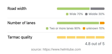
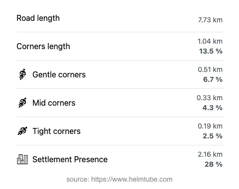
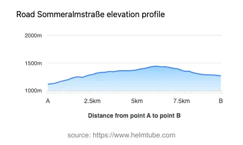
The Sommeralmstraße extends for approximately 7.7 km (4.8 miles), with an elevation range from 1,114 m (3,655 ft) to 1,443 m (4,734 ft). The road is predominantly wide (about 69%), with the remainder being of medium and narrow width. The surface is asphalt and is generally rated as excellent, providing a smooth and reliable riding experience. The road is gently curved, making it suitable for riders seeking a relaxed yet engaging journey. Two lanes are present for most of the route (about 92%), ensuring sufficient space for overtaking and maneuvering. The maximum speed limit is 50 km/h (31 mph), which is typical for mountain pass roads in Austria. Approximately 28% of the road passes through inhabited areas, while the remainder traverses open countryside and forested terrain.
Mountain Pass and Natural Attractions
The highlight of the Sommeralmstraße is the crossing of the Sommeralm mountain pass, which reaches an elevation of 1,400 m (4,593 ft). This pass is a notable feature within the Naturpark Almenland, a protected area known for its extensive alpine pastures and traditional farming culture. The road also traverses the Randgebirge östlich der Mur and the Steirische Voralpen, both subranges of the Alps. Riders can expect panoramic views of rolling meadows, distant peaks, and occasional glimpses of local wildlife. The area is popular for hiking, cycling, and agritourism, with several alpine huts and local cheese dairies accessible from the road.
Road Closures, Tolls, and Seasonal Considerations
The Sommeralmstraße is generally open to motorcycles, but seasonal closures may occur during winter months due to snow and adverse weather conditions. Riders are advised to check local resources or the Naturpark Almenland website for up-to-date information on accessibility. There is currently no toll or entrance fee specifically for motorcycles on this road. However, toll conditions may change in the future, and it is recommended to consult the ASFINAG website for the latest details on road tolls and vignettes in Austria. Event-related closures are rare but may occur during local festivals or organized cycling events.
Planning Your Ride and Additional Resources
When planning a ride on the Sommeralmstraße, it is advisable to monitor weather forecasts and road conditions, especially outside the summer season. The road’s excellent surface and moderate curves make it suitable for a range of motorcycle types, from touring bikes to sportier models. Facilities along the route are limited, so riders should plan fuel and refreshment stops in advance. For further information on the region, attractions, and current road status, the Naturpark Almenland website provides comprehensive resources. An interactive map of the Sommeralmstraße is available below to assist with route planning.
Explore the Region: Roads Close By
Discover more amazing roads located near the route featured in this article. The list below highlights nearby routes that are perfect for extending your ride or planning your next adventure.
Ride the Best: Austria’s Top Motorcycle Roads
These are the best motorbiking roads in Austria. The list below shows links to articles about top-rated motorcycle routes in the country. Explore the most popular roads in Austria and plan your next unforgettable motorbike adventure.