Exploring the Teichalm Alpine Road: A Motorcyclist’s Guide to Teichalmstraße 3184
Locals know best!
If you travel this road often or live close by you will be given a chance to provide your valuable rating soon! Sign in and stay connected.Location and Setting of Teichalmstraße 3184
Teichalmstraße 3184, also known as the Teichalm Alpine Road, is situated in the Austrian state of Styria. The route begins near the village of Fladnitz an der Teichalm and passes through the renowned Naturpark Almenland. This region is characterized by rolling alpine pastures, forested slopes, and a network of mountain ranges, including the Randgebirge östlich der Mur and the broader Alps. The road’s alignment provides access to several viewpoints and recreational areas, making it a popular choice for both local and visiting motorcyclists. An interactive map showing the route of Teichalmstraße 3184 can be found at the end of this article.
Road Characteristics and Riding Experience
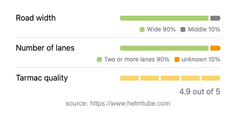
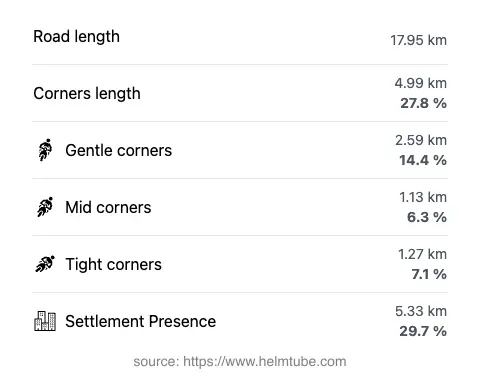
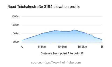
The Teichalm Alpine Road extends for approximately 17.96 km (11.2 miles), offering a ride that is gently curved rather than extremely twisty. The surface is asphalt and is maintained to a very high standard, providing a smooth and predictable riding experience. The road is predominantly wide (about 84%), with the remainder being of medium or narrow width. Most of the route features two lanes (about 89%), ensuring comfortable passage for both directions of traffic. Elevation along the road ranges from 698 m (2,290 ft) at its lowest point to 1,258 m (4,127 ft) at its highest, offering moderate altitude changes and expansive views of the surrounding landscape. The maximum speed limit varies between 50 km/h (31 mph) and 100 km/h (62 mph), depending on the section and proximity to inhabited areas. Approximately 29.7% of the road passes through settled regions, while the remainder traverses open countryside and forested terrain.
Natural Attractions and Points of Interest
One of the defining features of Teichalmstraße 3184 is its passage through Naturpark Almenland, a protected area known for its extensive alpine meadows and traditional farming culture. The road also crosses the Randgebirge östlich der Mur and skirts the Fischbacher Alpen, both of which contribute to the region’s varied topography. Along the route, riders will encounter several viewpoints that offer opportunities to stop and appreciate the landscape. The Teichalm area itself is a popular destination for outdoor activities, including hiking, cycling, and wildlife observation. The combination of natural beauty and accessible infrastructure makes this road a notable highlight for touring motorcyclists in Austria.
Seasonal Closures and Access Restrictions
Teichalmstraße 3184 is generally open to motorcycles throughout the year. However, due to its elevation and alpine setting, temporary closures can occur during winter months or in adverse weather conditions, particularly when snow or ice make the road unsafe. There are no permanent restrictions specifically targeting motorcycles. Riders are advised to check local traffic updates or consult the Naturpark Almenland website for current information on road conditions and potential closures related to weather or special events.
Tolls, Fees, and Practical Information
At present, there are no tolls or entrance fees required to ride the Teichalm Alpine Road. The route is a public road and is accessible without charge. However, toll conditions may change in the future, and it is recommended to verify the latest information before planning a trip. For up-to-date details on road tolls and entrance fees in Austria, riders can refer to the official ASFINAG toll information page. Parking fees may apply at certain attractions or viewpoints along the route, particularly within the Teichalm area.
Explore the Region: Roads Close By
Discover more amazing roads located near the route featured in this article. The list below highlights nearby routes that are perfect for extending your ride or planning your next adventure.
Ride the Best: Austria’s Top Motorcycle Roads
These are the best motorbiking roads in Austria. The list below shows links to articles about top-rated motorcycle routes in the country. Explore the most popular roads in Austria and plan your next unforgettable motorbike adventure.