Exploring the Villach–Arriach Mountain Route: A Motorcyclist’s Guide
Locals know best!
If you travel this road often or live close by you will be given a chance to provide your valuable rating soon! Sign in and stay connected.Location and Geographic Context
The Villach–Arriach route is situated in the southern Austrian state of Carinthia, beginning near the town of Villach and ending at the village of Arriach. The road crosses the Gurktal Alps, a subrange of the Central Eastern Alps, and briefly follows the Gegendtal valley. The region is characterized by a mix of alpine landscapes and inhabited areas, making it accessible yet distinctly mountainous. An interactive map showing the route can be found at the end of this article.
Road Details and Riding Experience
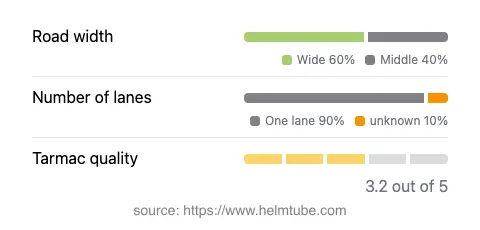
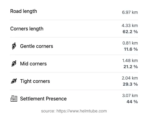
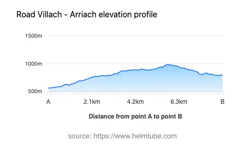
The Villach–Arriach road, locally known as Buchholzer Straße along part of its length, extends for approximately 7 km (4.3 miles). The route is predominantly wide (about 52%) and of medium width for a significant portion (41%), with a very small section classified as narrow. The surface is asphalt, with a quality rated as moderate—neither poor nor excellent, but generally reliable for motorcycle travel. The road is notably curvy, offering a riding experience that is engaging without being excessively technical. Most of the route consists of a single lane (about 94%), which requires attentive riding, especially in areas with oncoming traffic. The elevation ranges from 561 m (1,841 ft) at its lowest point to 980 m (3,215 ft) at its highest, providing a steady ascent through alpine terrain. Approximately 44% of the road passes through inhabited areas, offering occasional glimpses of local life amid the natural surroundings.
Natural Features and Points of Interest
The route’s passage through the Gurktal Alps is a highlight, with the landscape transitioning from the outskirts of Villach into the heart of the mountains. The Gegendtal valley, though only briefly followed by the road, adds to the diversity of scenery. Arriach, the endpoint of the route, is known as the geographical center of Carinthia and offers a glimpse into rural Austrian village life. Villach, at the other end, is a regional hub with historical sites, thermal baths, and access to the wider Alpine region. The road’s location makes it a practical link for riders exploring Carinthia or heading deeper into the Alps.
Road Closures, Seasonal Access, and Regulations
There are no permanent closures for motorcycles on the Villach–Arriach route. However, as with many alpine roads in Austria, temporary closures may occur due to weather conditions, particularly during winter months when snow and ice can make the road impassable. Riders are advised to check local traffic updates before planning a journey, especially outside the main riding season. No regular event-related closures have been reported for this route.
Tolls, Fees, and Practical Information
The Villach–Arriach road does not currently require a toll or entrance fee for motorcycles. Riders should note that toll conditions in Austria may change, and it is advisable to consult official resources for the most up-to-date information. For details on road tolls and vignette requirements in Austria, refer to the ASFINAG Vignette Information page. While this particular route is toll-free, other nearby alpine roads may have separate fee structures.
Explore the Region: Roads Close By
Discover more amazing roads located near the route featured in this article. The list below highlights nearby routes that are perfect for extending your ride or planning your next adventure.
Ride the Best: Austria’s Top Motorcycle Roads
These are the best motorbiking roads in Austria. The list below shows links to articles about top-rated motorcycle routes in the country. Explore the most popular roads in Austria and plan your next unforgettable motorbike adventure.