Exploring the Waldaist Valley Route: L-5 Road for Motorcyclists in Austria
Locals know best!
If you travel this road often or live close by you will be given a chance to provide your valuable rating soon! Sign in and stay connected.Location and Overview of the L-5 Road
The L-5 road is situated in the northern part of Austria, within the state of Upper Austria. It traverses the Waldaist Valley, running parallel to the Waldaist River for the majority of its length. The route connects rural landscapes and small settlements, with Pregarten being the nearest notable town at the eastern end of the road. The area is characterized by rolling hills, forested sections, and agricultural land, providing a varied backdrop for motorcyclists. An interactive map showing the precise route of the L-5 road can be found at the end of this article.
Technical Details of the L-5 Road
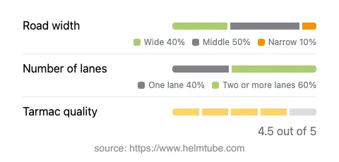
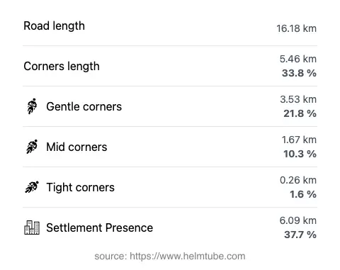
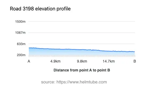
The L-5 road extends for approximately 16.2 km (10.1 miles), with an elevation range from 331 m (1,086 ft) to 485 m (1,591 ft). The road surface is asphalt and is generally of high quality, rated as very good. The route is moderately curvy, offering a mix of gently curved and straight sections, making it suitable for riders seeking a relaxed yet engaging ride. The road features a combination of one-lane and two-lane segments, with two lanes present for the majority (about 59%) of the route. In terms of width, the road is predominantly of medium width (50%), with wide sections accounting for about 38%. The maximum speed limit varies between 50 km/h (31 mph) and 100 km/h (62 mph), depending on the segment and proximity to inhabited areas. The road passes through or near inhabited areas for roughly 37.7% of its length, providing occasional access to local amenities.
Riding Along the Waldaist River
One of the defining features of the L-5 road is its close alignment with the Waldaist River. For approximately 93% of its length, the road runs adjacent to the river, offering riders frequent views of the waterway and the surrounding valley. The Waldaist River is a tributary of the Aist and is known for its clear waters and natural setting. The proximity to the river enhances the riding experience, especially during the warmer months when the valley is lush and green. The route is also popular among cyclists and local traffic, so riders should remain attentive, particularly in narrower sections and near settlements.
Road Closures, Seasonal Considerations, and Tolls
There are currently no known restrictions or closures specific to motorcycles on the L-5 road. The route is not a high-altitude mountain pass, so it generally remains open year-round, barring temporary closures due to roadworks or adverse weather conditions such as flooding. There are no tolls or entrance fees required to use the L-5 road. However, toll conditions and regulations may change in the future. For the most up-to-date information on road tolls and fees in Austria, riders should consult the official ASFINAG toll information website.
Nearby Attractions and Points of Interest
While the L-5 road itself is primarily a connector through rural Upper Austria, the nearby town of Pregarten offers local amenities and serves as a convenient base for exploring the region. The surrounding area is known for its traditional Austrian countryside, with opportunities for hiking, cycling, and visiting small villages. The Waldaist Valley is appreciated for its natural beauty and tranquility, making it a suitable destination for riders seeking a less crowded alternative to Austria's more famous alpine routes.
Explore the Region: Roads Close By
Discover more amazing roads located near the route featured in this article. The list below highlights nearby routes that are perfect for extending your ride or planning your next adventure.
Ride the Best: Austria’s Top Motorcycle Roads
These are the best motorbiking roads in Austria. The list below shows links to articles about top-rated motorcycle routes in the country. Explore the most popular roads in Austria and plan your next unforgettable motorbike adventure.