Exploring the Bregenz–Lindenberg Alpine Route: A Motorcyclist’s Guide
Locals know best!
If you travel this road often or live close by you will be given a chance to provide your valuable rating soon! Sign in and stay connected.Location and Overview of the Bregenz–Lindenberg Alpine Route
The Bregenz–Lindenberg Alpine Route is situated in western Austria, beginning near the town of Bregenz and extending towards Lindenberg im Allgäu in Germany. The road traverses the Allgäu Alps, a subrange of the greater Alps, and serves as a cross-border connector between Austria’s Vorarlberg region and the Bavarian Allgäu. The route passes through several small settlements, including Eichenberg and Ramsach, and is characterized by its proximity to alpine viewpoints and rural communities. An interactive map showing the route is available at the end of this article.
Road Characteristics and Riding Experience
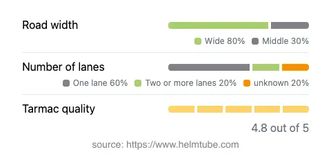
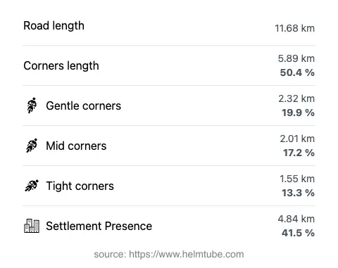
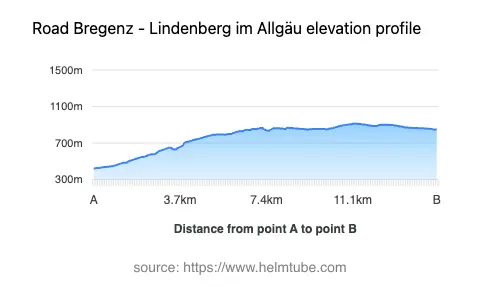
The Bregenz–Lindenberg Alpine Route covers approximately 11.7 km (7.3 miles), with elevations ranging from 424 m (1,391 ft) to 914 m (2,999 ft). The road surface is asphalt and is generally rated as excellent, providing a smooth and predictable riding experience. The route is moderately curvy, offering a mix of gently winding sections and more technical bends, making it suitable for riders seeking a balance between relaxed touring and engaging cornering. The road width varies, with the majority (about 72%) being wide enough for comfortable two-way traffic, while some sections are of medium width. Most of the route features one lane in each direction, with a smaller proportion offering two lanes. Speed limits vary along the route, typically set at 40, 50, or 60 km/h (25, 31, or 37 mph), reflecting the changing road conditions and proximity to inhabited areas.
Attractions and Points of Interest Along the Route
This alpine road is notable for its access to several viewpoints, offering expansive vistas of the Allgäu Alps and the surrounding valleys. While the route itself does not pass directly through major tourist centers, it provides access to the rural charm of settlements like Eichenberg and Ramsach. The proximity to the Allgäu Alps makes it a popular choice for riders interested in mountain landscapes. The starting point near Bregenz also allows for a detour to Lake Constance, a significant regional attraction. The road’s location within the alpine foothills ensures that riders can enjoy both natural beauty and the cultural atmosphere of the border region.
Seasonal Closures, Road Access, and Toll Information
The Bregenz–Lindenberg Alpine Route is generally open year-round, but riders should be aware that winter conditions can affect accessibility, particularly at higher elevations. Temporary closures may occur due to snow, ice, or maintenance work, especially during the colder months. There are currently no dedicated tolls or entrance fees for motorcycles on this route. However, toll conditions may change in the future, and riders are advised to consult the official Austrian toll information page for updates: ASFINAG Toll Information. Event-related closures are rare but may occur during local festivals or roadworks.
Practical Tips for Motorcyclists
Given the road’s excellent surface and moderate curviness, the Bregenz–Lindenberg Alpine Route is suitable for a wide range of motorcycles, from touring bikes to sportier models. Riders should remain attentive to changing road widths and the presence of local traffic, particularly in inhabited areas, which account for approximately 41.5% of the route. Weather conditions can change rapidly in the alpine environment, so appropriate gear and caution are recommended. For those interested in extending their journey, the proximity to the Allgäu Alps and Lake Constance offers additional opportunities for exploration. An interactive map of the route is provided below for further planning.
Explore the Region: Roads Close By
Discover more amazing roads located near the route featured in this article. The list below highlights nearby routes that are perfect for extending your ride or planning your next adventure.
Ride the Best: Austria’s Top Motorcycle Roads
These are the best motorbiking roads in Austria. The list below shows links to articles about top-rated motorcycle routes in the country. Explore the most popular roads in Austria and plan your next unforgettable motorbike adventure.