Exploring the Gurktal Alps: The Feldkirchen–Gurk Mountain Route for Motorcyclists
Locals know best!
If you travel this road often or live close by you will be given a chance to provide your valuable rating soon! Sign in and stay connected.Location and Geographic Context
The Feldkirchen–Gurk route is situated in the Austrian state of Carinthia, connecting the towns of Feldkirchen and Gurk. The road crosses the Gurktal Alps, a subrange of the Central Eastern Alps, and passes through the Oberkärnten region. The route is embedded within a landscape characterized by rolling alpine foothills, forested slopes, and rural settlements. The starting point is near Feldkirchen, a small town known for its proximity to the Ossiacher See, while the endpoint is close to Gurk, a historic market town. Along the way, the road passes through settlements such as Zammelsbergstraße, Pölling, Rennweg, and Weitensfeld. An interactive map showing the precise route can be found at the end of this article.
Road Characteristics and Riding Experience
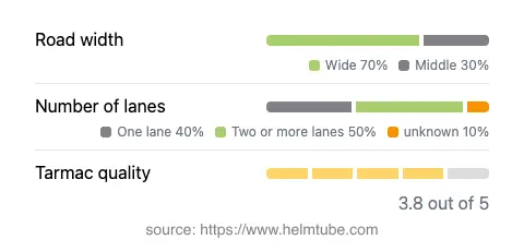
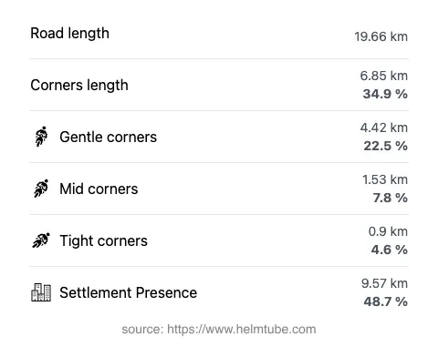
The Feldkirchen–Gurk Mountain Route covers approximately 19.7 km (12.2 miles), with an elevation range from 588 m (1,929 ft) to 1,100 m (3,609 ft). The road surface is asphalt, with a surface quality that can be described as generally good, though some sections may show moderate wear. The route is moderately curvy, offering a mix of gently winding stretches and more technical bends, making it suitable for riders seeking a balanced riding experience. The road features a combination of one-lane (about 40%) and two-lane (about 46%) sections, with the majority of the route being wide (about 68%), allowing for comfortable passing and maneuvering. Approximately half of the route passes through inhabited areas, providing a blend of rural and semi-urban riding environments. The maximum speed limit is 50 km/h (31 mph), reflecting the road’s alignment through villages and mountainous terrain.

Notable Attractions and Points of Interest
The route’s proximity to the Gurktal Alps provides riders with access to a region known for its natural beauty and traditional alpine culture. Near Feldkirchen, the Ossiacher See is a popular destination for outdoor activities. At the eastern end, Gurk is home to the Gurk Cathedral, a Romanesque basilica renowned for its architecture and historical significance. The road also passes close to the Goggausee, a small alpine lake favored by locals for swimming and relaxation. These attractions, combined with the rural charm of settlements like Weitensfeld and Pölling, make the route appealing for riders interested in both motorcycling and cultural exploration.
Seasonal Closures and Accessibility
The Feldkirchen–Gurk Mountain Route is generally open to motorcycles throughout the year. However, due to its elevation and alpine location, temporary closures can occur during winter months or periods of heavy snowfall, particularly on higher sections. Riders are advised to check local traffic reports or the ASFINAG Traffic Information service for up-to-date information on road conditions and any event-related closures before planning their journey.
Tolls, Fees, and Practical Information
There are currently no tolls or entrance fees required for motorcycles on the Feldkirchen–Gurk Mountain Route. Riders should note that toll conditions may change in the future, and it is recommended to consult the ASFINAG Toll Information website for the latest updates on tolls and vignettes applicable to Austrian roads. The route is well-maintained, but as with many alpine roads, weather and surface conditions can vary, so appropriate caution is advised.
Explore the Region: Roads Close By
Discover more amazing roads located near the route featured in this article. The list below highlights nearby routes that are perfect for extending your ride or planning your next adventure.
Ride the Best: Austria’s Top Motorcycle Roads
These are the best motorbiking roads in Austria. The list below shows links to articles about top-rated motorcycle routes in the country. Explore the most popular roads in Austria and plan your next unforgettable motorbike adventure.