Motorcycling the Sankt Veit an der Glan – Gurk Alpine Route
Locals know best!
If you travel this road often or live close by you will be given a chance to provide your valuable rating soon! Sign in and stay connected.Location and Overview
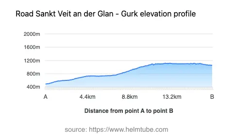
The Sankt Veit an der Glan – Gurk route is situated in the southern Austrian state of Carinthia, traversing the Gurktaler Alps. The road begins near the town of Sankt Veit an der Glan and concludes in the historic town of Gurk, passing through the settlement of Spitalgasse. This region is characterized by its alpine landscapes, with elevations ranging from 491 m (1,611 ft) to 1,118 m (3,668 ft). The area is known for its rural charm and proximity to the Gurk River valley. An interactive map showing the route can be found at the end of the article.
Road Characteristics and Riding Experience
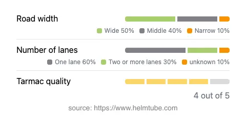
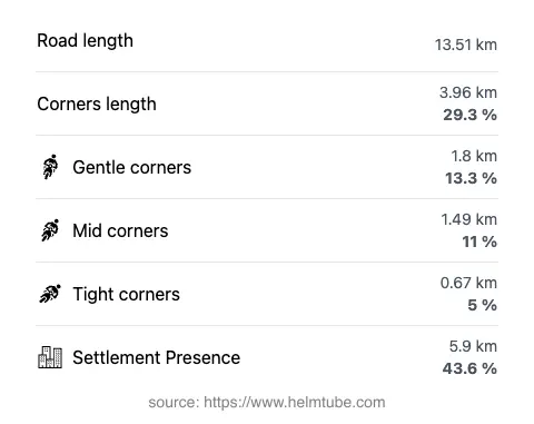
The road covers a distance of approximately 13.5 km (8.4 miles), offering a moderately twisty ride suitable for a range of skill levels. The surface is asphalt and generally in good condition, rated as high quality. Riders will encounter a mix of one-lane (about 59%) and two-lane (about 33%) sections, with the majority of the road being wide (about 51%), and a significant portion of medium width. Narrow segments are limited. The route passes through both inhabited and rural areas, with roughly 44% of the journey traversing settlements. The maximum speed limits are 50 km/h (31 mph) and 70 km/h (43 mph), depending on the section. The road ascends and descends through the Gurktaler Alps, providing elevation changes that add to the riding interest.
Notable Attractions and Points of Interest
The route is closely associated with the Gurktaler Alps, a subrange of the Central Eastern Alps. The town of Gurk is notable for the Gurk Cathedral, a Romanesque basilica and a significant pilgrimage site. Sankt Veit an der Glan, the starting point, is known for its medieval old town and annual flower festival. The surrounding alpine scenery and rural settlements provide a backdrop that is typical of Carinthia’s less-traveled roads. Riders may also encounter local agricultural activity and traditional Austrian villages along the way.
Road Closures and Seasonal Considerations
There are no permanent closures for motorcycles on this route. However, as with many alpine roads in Austria, temporary closures may occur due to weather conditions, particularly in winter months when snow and ice can make the road impassable. Riders are advised to check local traffic updates before departure, especially outside the main riding season. Event-related closures are rare but possible during local festivals or road maintenance.
Tolls, Fees, and Practical Information
There are currently no tolls or entrance fees required to ride the Sankt Veit an der Glan – Gurk route. Riders should note that toll conditions may change in the future, and it is advisable to consult official resources for the most up-to-date information. For general information on road tolls and fees in Austria, visit the ASFINAG website. Fuel stations and basic amenities are available in Sankt Veit an der Glan and Gurk, but options are limited along the route itself.
Explore the Region: Roads Close By
Discover more amazing roads located near the route featured in this article. The list below highlights nearby routes that are perfect for extending your ride or planning your next adventure.
Ride the Best: Austria’s Top Motorcycle Roads
These are the best motorbiking roads in Austria. The list below shows links to articles about top-rated motorcycle routes in the country. Explore the most popular roads in Austria and plan your next unforgettable motorbike adventure.