Exploring the Simonhöhe Straße: A Motorcyclist’s Guide to the Gurktaler Alps
Locals know best!
If you travel this road often or live close by you will be given a chance to provide your valuable rating soon! Sign in and stay connected.Location and Regional Context
The Simonhöhe Straße is situated in the Austrian state of Carinthia, within the Oberkärnten region. The road crosses the Gurktaler Alps, a subrange of the Central Eastern Alps, and is positioned northeast of the town of Feldkirchen. The route connects the settlements of Simonhöhe Straße and Urbanstraße, serving as a local connector through alpine terrain. The area is characterized by forested slopes, mountain meadows, and proximity to the Simonhöhe ski and recreation area, which is a notable destination for both winter and summer activities. An interactive map showing the Simonhöhe Straße can be found at the end of this article.
Road Characteristics and Riding Experience
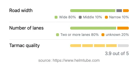
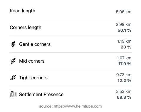
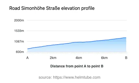
The Simonhöhe Straße extends for approximately 6 km (3.7 miles), with elevations ranging from 741 m (2,431 ft) at its lowest point to 1,228 m (4,029 ft) at its highest. The road surface is asphalt, with a generally good quality rating, offering a stable and predictable riding experience. The route is moderately curvy, providing a mix of gently winding sections and some straighter stretches, making it suitable for riders seeking a relaxed pace rather than technical challenge. The road is predominantly wide (about 85%), with the remainder being of medium width, and features two lanes for most of its length (about 85%). The maximum speed limit is 30 km/h (19 mph), reflecting the road’s local and recreational character. Approximately 59% of the route passes through inhabited or semi-inhabited areas, so riders should remain attentive to local traffic and possible agricultural vehicles.
Local Attractions and Points of Interest
The Simonhöhe area is best known for the Simonhöhe ski resort, which attracts visitors year-round for skiing, hiking, and mountain biking. The nearby town of Feldkirchen in Kärnten offers amenities, historical sites, and serves as a gateway to the Gurktaler Alps. The Gurktaler Alps themselves are a significant natural feature, providing opportunities for outdoor recreation and panoramic views. While the Simonhöhe Straße is not a major alpine pass, it offers access to these attractions and serves as a practical route for exploring the region’s landscapes and rural communities.
Road Closures, Seasonal Access, and Practical Considerations
The Simonhöhe Straße is generally open to motorcyclists throughout the year, but seasonal closures may occur due to snow accumulation or maintenance, particularly during the winter months. Riders should check local advisories or contact the ASFINAG road conditions service for up-to-date information on accessibility. There are no permanent restrictions for motorcycles, but temporary closures can be implemented during adverse weather or special events. It is advisable to verify the current status before planning a ride, especially outside the main summer season.
Tolls, Fees, and Additional Information
There is currently no toll or entrance fee required to use the Simonhöhe Straße. However, toll conditions in Austria are subject to change, and riders should consult official sources for the most current information. For comprehensive details on road tolls and vignettes in Austria, refer to the ASFINAG toll information page. Always ensure compliance with local regulations and carry the appropriate documentation when riding in Austria.
Explore the Region: Roads Close By
Discover more amazing roads located near the route featured in this article. The list below highlights nearby routes that are perfect for extending your ride or planning your next adventure.
Ride the Best: Austria’s Top Motorcycle Roads
These are the best motorbiking roads in Austria. The list below shows links to articles about top-rated motorcycle routes in the country. Explore the most popular roads in Austria and plan your next unforgettable motorbike adventure.