Exploring the Pustertaler Höhenstraße: Lienz to Sillian by Motorcycle
Locals know best!
If you travel this road often or live close by you will be given a chance to provide your valuable rating soon! Sign in and stay connected.Location and Overview of the Pustertaler Höhenstraße
The Pustertaler Höhenstraße, connecting the towns of Lienz and Sillian in the Austrian state of Tyrol, traverses the southern edge of the Alps. The road runs parallel to the main Puster Valley (Hochpustertal - Alta Pusteria), offering elevated perspectives over the valley floor. The route is situated in the district of Lienz, with the starting point near the town of Lienz and the endpoint close to Sillian, both of which are accessible via the B100 Drautalstraße. The road is well-known among local and visiting motorcyclists for its combination of mountain and valley riding. An interactive map showing the route can be found at the end of this article.
Road Characteristics and Riding Experience
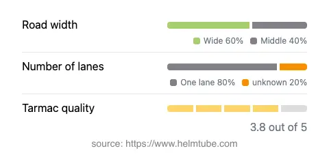
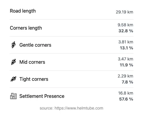
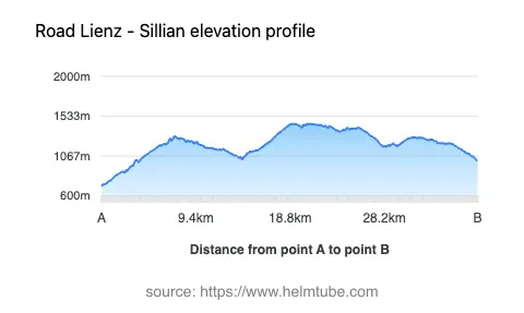
The Pustertaler Höhenstraße is approximately 29.2 km (18.1 miles) in length, with an asphalt surface of generally good quality. Riders will encounter a moderately twisty alignment, with a mix of gently curved and more technical sections. The majority of the road is wide (about 63%), with some stretches of medium width (about 35%), providing comfortable passage for motorcycles. Most of the route is single-lane (about 75%), with a small proportion offering two lanes (about 4%). The elevation ranges from 716 m (2,349 ft) to 1,447 m (4,747 ft), and the road passes through several inhabited areas, accounting for more than half of its length. The maximum speed limit is 50 km/h (31 mph), reflecting the road's alignment and the presence of settlements along the way.
Geographical Features and Attractions
This route is notable for its passage through multiple valleys, including the Hochpustertal (Puster Valley), Lienzer Talboden, Wilfernertal, and Kristeinertal. The road also crosses several subranges of the Alps, such as the Winkeltaler Berge and Regenstein-Kette. Along the way, riders will find several viewpoints that offer expansive vistas of the surrounding mountains and valleys. These viewpoints are popular stops for photography and short breaks, providing a chance to appreciate the landscape of the Tyrolean Alps. The proximity to the towns of Lienz and Sillian also allows for convenient access to local amenities and cultural sites.
Seasonal Closures, Road Tolls, and Practical Information
The Pustertaler Höhenstraße is generally open to motorcycles throughout the year, but temporary closures may occur due to weather conditions, particularly in winter months when snow or ice can make the road impassable. Riders are advised to check local traffic reports or the ASFINAG traffic information service for up-to-date closure information. Currently, there is no toll or entrance fee required for motorcycles on this road. However, toll conditions may change in the future, and riders should consult the ASFINAG toll information page for the latest details on road charges in Austria.
Planning Your Ride and Additional Resources
When planning a ride along the Pustertaler Höhenstraße, it is advisable to consider the weather, as conditions in the Alps can change rapidly. The road's moderate curviness and generally good surface make it suitable for a range of motorcycle types, though caution is recommended in inhabited areas and at viewpoints where traffic may slow. For those interested in extending their journey, the nearby towns of Lienz and Sillian offer accommodation, dining, and access to further alpine routes. For more information on the region, riders can consult resources such as Lonely Planet: Lienz and Tripadvisor: Sillian. An interactive map of the Pustertaler Höhenstraße is available below to assist with route planning.
Explore the Region: Roads Close By
Discover more amazing roads located near the route featured in this article. The list below highlights nearby routes that are perfect for extending your ride or planning your next adventure.
Ride the Best: Austria’s Top Motorcycle Roads
These are the best motorbiking roads in Austria. The list below shows links to articles about top-rated motorcycle routes in the country. Explore the most popular roads in Austria and plan your next unforgettable motorbike adventure.