Gollersattel Pass Road: Motorcycling Through Naturpark Almenland
Locals know best!
If you travel this road often or live close by you will be given a chance to provide your valuable rating soon! Sign in and stay connected.Location and Overview of Gollerstraße
Gollerstraße is situated in the Austrian state of Styria, connecting the town of Weiz with the village of Hart. The road traverses the Randgebirge östlich der Mur, a subrange of the Styrian Prealps, and forms a key passage through the Naturpark Almenland. The route’s proximity to the Raab river and its passage over the Gollersattel mountain pass make it a distinctive option for motorcyclists exploring the region. An interactive map showing the road can be found at the end of the article.
Road Characteristics and Riding Experience
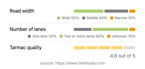
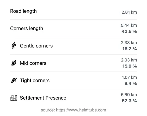
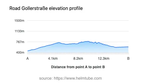
The Gollerstraße extends for approximately 12.8 km (8 miles), with a route profile that is moderately twisty, offering a mix of gently curved and more technical sections. The road surface is asphalt and is generally regarded as being of high quality, providing a smooth and predictable riding experience. Most of the route features two lanes (about 61%), with the remainder alternating between one-lane stretches and wider segments. The width is predominantly wide (about 45%), with middle-width sections making up a significant portion as well. Riders should be aware that over half of the road passes through inhabited areas, which may require additional caution due to local traffic and potential agricultural vehicles. Elevation ranges from 457 m (1,499 ft) at its lowest point to 786 m (2,579 ft) at its highest, with the Gollersattel pass itself reaching 789 m (2,589 ft). The road’s alignment along the Raab river for a portion of its length adds to the variety of the landscape encountered.
Key Attractions and Points of Interest
One of the defining features of this route is its passage through Naturpark Almenland, a protected area known for its traditional alpine pastures, diverse flora and fauna, and rural cultural heritage. The Gollersattel pass, which the road is named after, is a modest but historically significant crossing in the region. The nearby town of Weiz serves as a convenient starting point, offering amenities and access to local attractions. The route also skirts the Raab river, which ultimately flows into the Danube, and provides occasional views of the surrounding Alps. For those interested in extending their journey, the broader Almenland region is renowned for its cheese production and traditional Styrian cuisine.
Seasonal Accessibility and Road Regulations
The Gollerstraße is generally open to motorcyclists throughout the year, but riders should be aware that winter conditions in the Styrian Alps can lead to temporary closures or hazardous riding surfaces due to snow and ice, particularly at higher elevations such as the Gollersattel pass. There are no permanent restrictions on motorcycle access, but local authorities may impose temporary closures for maintenance or during adverse weather events. It is advisable to check with the Naturpark Almenland website or local traffic information services before planning a ride, especially outside the main riding season.
Tolls, Fees, and Practical Information
Currently, there are no tolls or entrance fees required to ride the Gollerstraße or to cross the Gollersattel pass. However, toll conditions may change in the future, and riders are encouraged to verify the latest information through official Austrian transport resources. For up-to-date details on road tolls and regulations in Austria, consult the ASFINAG website. Fuel and basic services are available in Weiz and other nearby settlements, but options may be limited along the more remote stretches of the route.
Explore the Region: Roads Close By
Discover more amazing roads located near the route featured in this article. The list below highlights nearby routes that are perfect for extending your ride or planning your next adventure.
Ride the Best: Austria’s Top Motorcycle Roads
These are the best motorbiking roads in Austria. The list below shows links to articles about top-rated motorcycle routes in the country. Explore the most popular roads in Austria and plan your next unforgettable motorbike adventure.