Griffner Berg Pass: Motorcycling the Völkermarkt–Sankt Andrä Route
Locals know best!
If you travel this road often or live close by you will be given a chance to provide your valuable rating soon! Sign in and stay connected.Location and Overview
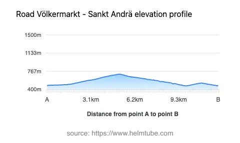
The Griffner Berg Pass road runs between the towns of Völkermarkt and Sankt Andrä in the southern Austrian state of Carinthia. The route follows the Packer Straße (B70), a regional road that serves as a key connector across the Lavanttaler Alpen. The pass itself, Griffner Berg, sits at an elevation of 708 m (2,323 ft), providing a modest ascent and descent through the alpine foothills. The road is situated within a region characterized by rolling hills, forested slopes, and agricultural land, with the Lavanttaler Alpen and Saualpe mountain ranges forming the backdrop. An interactive map showing the route is available at the end of this article.
Road Characteristics and Riding Experience
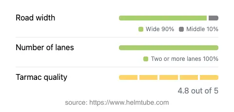
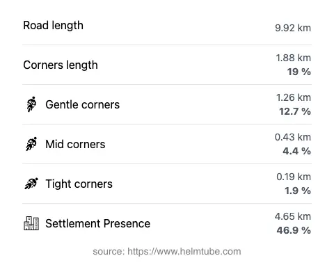
The Völkermarkt–Sankt Andrä route via Griffner Berg Pass covers a distance of approximately 9.9 km (6.2 miles). The road is predominantly wide (about 90%), with a two-lane configuration throughout nearly the entire stretch. Surface quality is rated as excellent, with smooth asphalt providing reliable grip and comfort for motorcyclists. The route is gently curved, making it suitable for riders of all skill levels, and is not considered particularly twisty compared to other alpine passes. The elevation ranges from 475 m (1,558 ft) at its lowest point to 709 m (2,326 ft) at the summit of the pass. The maximum speed limit along the route is 50 km/h (31 mph), reflecting the presence of inhabited areas and the road’s regional character. Nearly half of the road passes through or near settlements, offering occasional opportunities for rest stops and refreshments.
Mountain Pass and Surrounding Attractions
The highlight of this route is the crossing of Griffner Berg, a mountain pass that serves as a gateway between the Lavant Valley and the Jaun Valley. The pass is part of the Lavanttaler Alpen, a lesser-known but picturesque subrange of the Alps. Riders traversing this road will also skirt the Saualpe, a long ridge known for its hiking trails and panoramic views. While the road itself is primarily functional, the surrounding region offers several points of interest. Völkermarkt, the starting point, is a historic town with a medieval center and the Völkermarkt Castle ruins. Sankt Andrä, at the other end, is home to the St. Andrew's Abbey, a Benedictine monastery with a rich history. The Lavant Valley itself is known for its orchards and traditional Austrian countryside.
Road Access, Closures, and Fees
The Griffner Berg Pass road is open to motorcycles year-round, with no regular seasonal closures. However, as with many alpine routes, temporary closures may occur due to severe weather, roadworks, or local events. Riders are advised to check local traffic information before departure. There are currently no tolls or entrance fees required to use this section of the Packer Straße (B70). Toll conditions may change in the future, so it is recommended to consult the ASFINAG website for up-to-date information on road tolls and regulations in Austria.
Planning Your Ride
For motorcyclists seeking a reliable and accessible alpine route, the Griffner Berg Pass offers a straightforward ride with excellent road conditions. The gentle curves and wide lanes make it suitable for touring motorcycles and less experienced riders, while the surrounding landscape provides a pleasant backdrop. The proximity to Völkermarkt and Sankt Andrä allows for easy access to amenities, historical sites, and local cuisine. Riders interested in exploring further can use this route as a gateway to the broader Lavant Valley and the Carinthian Alps. For navigation and trip planning, an interactive map of the Griffner Berg Pass route is provided below.
Explore the Region: Roads Close By
Discover more amazing roads located near the route featured in this article. The list below highlights nearby routes that are perfect for extending your ride or planning your next adventure.
Ride the Best: Austria’s Top Motorcycle Roads
These are the best motorbiking roads in Austria. The list below shows links to articles about top-rated motorcycle routes in the country. Explore the most popular roads in Austria and plan your next unforgettable motorbike adventure.