Exploring the Schwarzenbachbrücke Route through Naturpark Landseer Berge
Locals know best!
If you travel this road often or live close by you will be given a chance to provide your valuable rating soon! Sign in and stay connected.Location and Setting of the Schwarzenbachbrücke Route
The Schwarzenbachbrücke 3569 is situated in eastern Austria, passing through the settlement of Schwarzenbachbrücke and traversing the Naturpark Landseer Berge. The road lies within the Randgebirge östlich der Mur, a subrange of the Alps, and is characterized by its proximity to natural landscapes and viewpoints. The region is known for its rolling hills, forested areas, and the presence of protected parkland, making it a distinctive area for motorcycle touring. An interactive map showing the route of the Schwarzenbachbrücke 3569 can be found at the end of this article.
Road Characteristics and Riding Experience
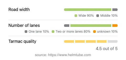
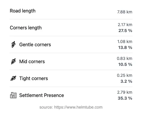
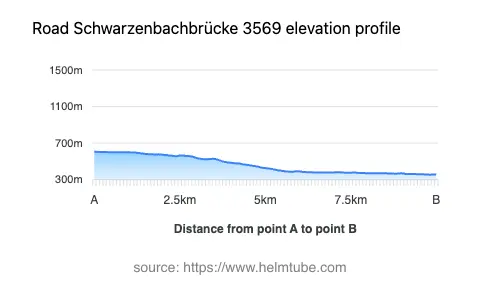
The Schwarzenbachbrücke 3569 extends for approximately 7.9 km (4.9 miles), with elevations ranging from 355 m (1,165 ft) to 606 m (1,988 ft). The road surface is asphalt and is generally of high quality, offering a smooth ride for most of its length. Riders will encounter a moderately curvy alignment, providing a balance between relaxed cruising and technical engagement. The majority of the route consists of two lanes (about 81%), with the remainder being single-lane sections. The road is predominantly wide (about 86%), allowing for comfortable passage and overtaking where permitted. Approximately 35% of the route passes through inhabited areas, while the rest winds through natural and semi-rural landscapes. The maximum speed limit is 50 km/h (31 mph), reflecting the road's passage through a national park and its focus on safety and environmental preservation.
Natural Attractions and Points of Interest
One of the defining features of the Schwarzenbachbrücke 3569 is its passage through the Naturpark Landseer Berge. This nature park is recognized for its biodiversity, forested hills, and panoramic viewpoints. Riders can expect occasional opportunities to stop and appreciate the landscape, particularly at designated viewpoints along the route. The road also crosses the Randgebirge östlich der Mur, a lesser-known mountain range that forms part of the broader Alps. These geographical features contribute to the road's appeal for those interested in both motorcycling and nature observation.
Access, Closures, and Regulations
The Schwarzenbachbrücke 3569 is open to motorcyclists and does not have any specific restrictions against motorcycle traffic. However, as the road passes through a protected nature park, riders should be aware of potential seasonal closures or temporary restrictions due to park management activities or adverse weather conditions, particularly in winter months. It is advisable to consult local authorities or the Austria.info Traffic Regulations page for up-to-date information on road status and regulations. Event-related closures are rare but may occur during park events or maintenance periods.
Tolls, Fees, and Further Information
Currently, there are no tolls or entrance fees required to access the Schwarzenbachbrücke 3569 or the Naturpark Landseer Berge for motorcycles. Riders should note that toll conditions may change in the future, and it is recommended to verify the latest information before planning a trip. For comprehensive details on road tolls and entrance fees in Austria, refer to the ASFINAG Toll Information website.
Explore the Region: Roads Close By
Discover more amazing roads located near the route featured in this article. The list below highlights nearby routes that are perfect for extending your ride or planning your next adventure.
Ride the Best: Austria’s Top Motorcycle Roads
These are the best motorbiking roads in Austria. The list below shows links to articles about top-rated motorcycle routes in the country. Explore the most popular roads in Austria and plan your next unforgettable motorbike adventure.