Kniepass Road: Crossing the Alps Between Reutte and Vils
Locals know best!
If you travel this road often or live close by you will be given a chance to provide your valuable rating soon! Sign in and stay connected.Location and Route Overview
The Kniepass Road is situated in western Austria, within the federal state of Tyrol. It links the towns of Reutte and Vils, passing through the Kniepass at an elevation of 872 m (2,861 ft). The route lies in the Ammergau Alps, a subrange of the northern Alps, and closely follows the Lech River for a significant portion of its length. The road also traverses the Ranzental valley, providing a varied alpine setting. An interactive map showing the precise route of the Kniepass Road can be found at the end of this article.
Road Characteristics and Riding Experience
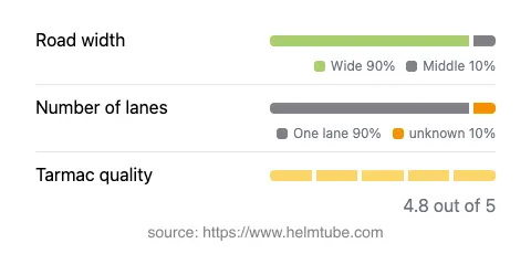
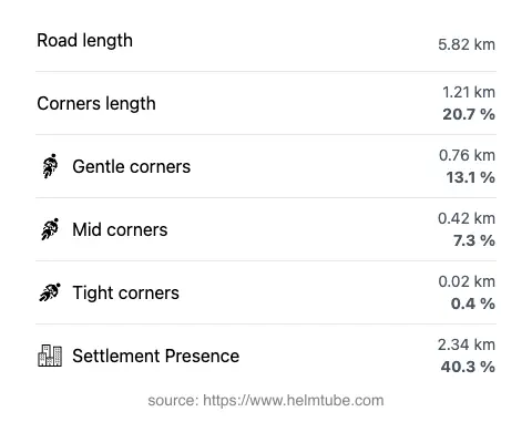
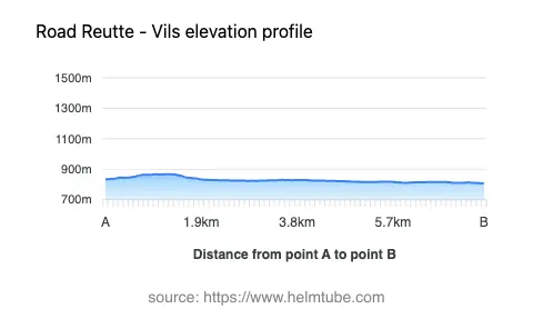
The Kniepass Road extends for approximately 5.8 km (3.6 miles), with the majority of its surface composed of high-quality asphalt. The road is generally wide (about 90%), with a small proportion of middle-width sections and virtually no narrow stretches. Most of the route consists of a single lane in each direction, with a minor segment offering two lanes. The alignment is moderately curvy, providing a mix of gently sweeping bends and a few tighter corners, but it is not considered extremely twisty. The elevation ranges from 807 m (2,648 ft) to 867 m (2,844 ft), with the highest point at the Kniepass itself. Riders will encounter a maximum speed limit of 100 km/h (62 mph) in some sections, with other stretches limited to 70 km/h (43 mph) or 50 km/h (31 mph), depending on proximity to inhabited areas. The road passes through both open alpine terrain and settled zones, with about 40% of its length running through inhabited areas. Surface quality is rated as excellent, ensuring a comfortable and predictable ride for motorcyclists.
Natural Features and Attractions Along the Route
The Kniepass Road is notable for its proximity to several natural features. It runs parallel to the Lech River for a substantial portion, offering occasional river views and access to riverside stops. The route also passes through the Ranzental valley, a lesser-known but picturesque alpine valley. The surrounding region is part of the Ammergau Alps, known for their rugged limestone peaks and forested slopes. Riders will find at least one designated viewpoint along the road, providing an opportunity to pause and take in the alpine scenery. The area is also a gateway to further exploration of the Alps, with numerous hiking and sightseeing options nearby.
Road Closures, Seasonal Access, and Regulations
The Kniepass Road is generally open to motorcyclists throughout the year, but temporary closures may occur due to adverse weather conditions, particularly in winter months when snow or ice can make the pass hazardous. There are no permanent restrictions on motorcycle access. Riders should be aware that local authorities may impose short-term closures for maintenance or special events. It is advisable to check the ASFINAG Traffic Reports for up-to-date information on road conditions and closures before planning a trip.
Tolls, Fees, and Further Information
There is currently no toll or entrance fee required to ride the Kniepass Road. However, toll conditions in Austria may change, and certain nearby highways or alpine routes may require a vignette or separate payment. For the latest details on tolls and road fees in Austria, consult the ASFINAG Vignette Information page. Riders are encouraged to verify current requirements before setting out, especially if planning to use other major roads in the region.
Explore the Region: Roads Close By
Discover more amazing roads located near the route featured in this article. The list below highlights nearby routes that are perfect for extending your ride or planning your next adventure.
Ride the Best: Austria’s Top Motorcycle Roads
These are the best motorbiking roads in Austria. The list below shows links to articles about top-rated motorcycle routes in the country. Explore the most popular roads in Austria and plan your next unforgettable motorbike adventure.