Exploring the Losenegg 3129: A Technical Ride Through Austria’s Heartland
Locals know best!
If you travel this road often or live close by you will be given a chance to provide your valuable rating soon! Sign in and stay connected.Location and Setting of the Losenegg 3129
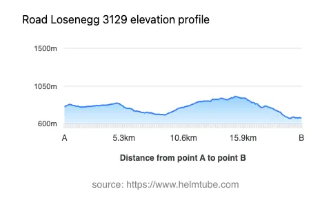
The Losenegg 3129 is situated in Austria, traversing the region near the village of Losenegg and extending towards Sankt Oswald. The road lies within the central part of the country, characterized by rolling hills and a mix of forested and agricultural landscapes. This area is not typically associated with Austria’s high alpine passes, but it offers a distinct rural experience with moderate elevation ranging from 665 m (2,182 ft) to 927 m (3,041 ft). The route is accessible from several nearby settlements, making it a practical option for riders seeking to explore Austria’s countryside. An interactive map showing the precise route of the Losenegg 3129 can be found at the end of this article.
Technical Details and Riding Experience
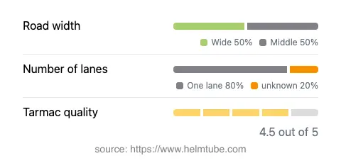
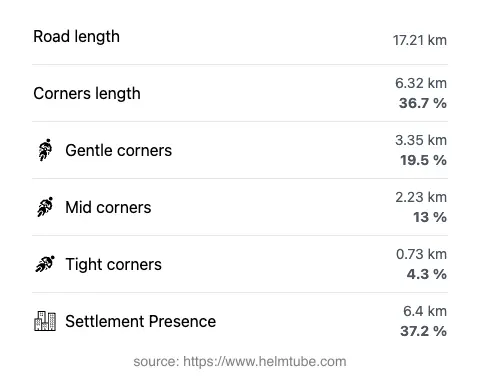
The Losenegg 3129 covers a distance of approximately 17.2 km (10.7 miles), with the majority of the road featuring a gently curved alignment. The road surface is asphalt and is generally rated as very good, providing a comfortable ride for most motorcycles. Surface quality is high, with only minor imperfections noted. The road is predominantly one lane (about 79%), with a small portion offering two lanes (about 4%). In terms of width, the route alternates between middle and wide sections, with wide stretches making up the largest proportion (about 44%). Riders should be prepared for occasional narrow segments, particularly in areas closer to settlements. The route passes through inhabited areas for roughly 37% of its length, offering glimpses of local village life and rural scenery.
Local Attractions and Points of Interest
While the Losenegg 3129 does not pass directly by major tourist attractions, its proximity to the village of Sankt Oswald provides an opportunity to experience traditional Austrian village culture. The surrounding region is known for its picturesque countryside, dotted with small farms and woodlands. Riders interested in exploring further can visit the nearby Wachau Valley, a UNESCO World Heritage site renowned for its vineyards and historic towns, though it is located some distance from the Losenegg 3129. The road itself is best appreciated for its tranquil setting and the technical riding experience it offers, rather than for specific tourist destinations along its length.
Road Closures, Seasonal Access, and Practical Considerations
There are no known permanent closures for motorcycles on the Losenegg 3129. The road remains open throughout the year, although temporary closures may occur due to maintenance or adverse weather conditions, particularly in winter months when snow and ice can impact accessibility. Riders are advised to check local traffic updates before planning their journey. There are currently no tolls or entrance fees required to use this road. However, toll conditions may change in the future, and it is recommended to consult the official Austrian toll information page for the most up-to-date details: ASFINAG Toll Information.
Planning Your Ride: Safety and Navigation
Given the road’s mix of gently curved and occasionally narrow sections, riders should exercise caution, especially in areas with limited visibility or near inhabited zones. The elevation changes are moderate, and the road surface is generally reliable, but weather conditions can vary rapidly. It is advisable to equip your motorcycle with appropriate tires for changing conditions, particularly if riding outside the summer months. Navigation is straightforward, with clear signage along the route, but carrying a GPS device or a detailed map is recommended for first-time visitors. For those seeking a technical but accessible ride through Austria’s countryside, the Losenegg 3129 offers a rewarding experience. An interactive map of the route is available below to assist with trip planning.
Explore the Region: Roads Close By
Discover more amazing roads located near the route featured in this article. The list below highlights nearby routes that are perfect for extending your ride or planning your next adventure.
Ride the Best: Austria’s Top Motorcycle Roads
These are the best motorbiking roads in Austria. The list below shows links to articles about top-rated motorcycle routes in the country. Explore the most popular roads in Austria and plan your next unforgettable motorbike adventure.