Moarigrabensattel Pass Road: Motorcycling Through the Türnitzer Alps
Locals know best!
If you travel this road often or live close by you will be given a chance to provide your valuable rating soon! Sign in and stay connected.Location and Regional Context
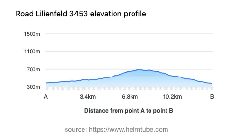
The Moarigrabensattel Pass Road is situated in Lower Austria, within the broader expanse of the Austrian Alps. The route begins near the town of Lilienfeld and passes through the Morigrabenstraße, ascending to the Moarigrabensattel mountain pass at 687 m (2,254 ft) before descending towards the valley settlements. The road crosses the Türnitzer Alpen and skirts the Gutensteiner Alpen, providing access to several valleys, including Moarigraben, Fußtal, Lenesgraben, and Tradigistgraben. This region is less frequented by international tourists compared to the central Alps, offering a quieter riding experience. An interactive map showing the route can be found at the end of the article.
Road Characteristics and Riding Experience
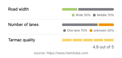
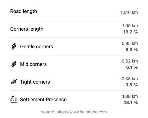
The Moarigrabensattel Pass Road extends for approximately 10.2 km (6.3 miles), with elevations ranging from 385 m (1,263 ft) to 701 m (2,300 ft). The road surface is asphalt and is generally rated as excellent, providing a smooth and reliable riding experience. The route is moderately curvy, offering a mix of gently winding sections and a few tighter bends, making it suitable for riders seeking a balance between technical challenge and relaxed touring. The road is predominantly of medium width (about 68%), with some wider sections (about 29%) that facilitate easier passing and maneuvering. One-lane segments are present along much of the route (about 68%), so caution is advised, especially in areas with limited visibility. The maximum speed limits vary between 50 km/h (31 mph), 70 km/h (43 mph), and 100 km/h (62 mph), depending on the section and proximity to inhabited areas. Nearly half of the road passes through or near settlements, which may require additional attention to local traffic and pedestrians.
Mountain Pass and Surrounding Geography
The highlight of the route is the crossing of the Moarigrabensattel, a mountain pass at 687 m (2,254 ft) that serves as a gateway between the valleys of the Türnitzer Alpen. The road also provides views of the Türnitzer Alpen and skirts the edge of the Gutensteiner Alpen. The valleys along the route, such as Moarigraben and Lenesgraben, contribute to the varied landscape, with forested slopes and occasional clearings. The region is known for its rural charm and is less developed than other alpine areas, making it appealing for riders seeking a quieter, more authentic Austrian mountain experience.
Road Closures, Seasonal Access, and Tolls
There are no permanent closures for motorcycles on the Moarigrabensattel Pass Road. However, as with many alpine routes in Austria, temporary closures may occur during winter months due to snow or adverse weather conditions. It is advisable to check local traffic information before planning a ride, especially outside the main riding season. There are currently no tolls or entrance fees required to use this road. Riders should be aware that toll conditions may change in the future. For up-to-date information on road tolls and regulations in Austria, consult the ASFINAG website.
Nearby Attractions and Practical Information
The town of Lilienfeld serves as the nearest major settlement and is known for its historic Cistercian Abbey, which is a notable local attraction. The surrounding Türnitzer Alpen region offers opportunities for hiking and nature observation, with several marked trails accessible from the valleys adjacent to the road. While the area is not heavily touristed, it provides a peaceful setting for riders interested in exploring rural Austria. Facilities such as fuel stations and restaurants are available in Lilienfeld, but options become limited further along the route, so planning ahead is recommended. For those interested in extending their journey, the broader Alps region offers numerous additional routes and points of interest.
Explore the Region: Roads Close By
Discover more amazing roads located near the route featured in this article. The list below highlights nearby routes that are perfect for extending your ride or planning your next adventure.
Ride the Best: Austria’s Top Motorcycle Roads
These are the best motorbiking roads in Austria. The list below shows links to articles about top-rated motorcycle routes in the country. Explore the most popular roads in Austria and plan your next unforgettable motorbike adventure.