Riding the Pielachtaler Gscheid Pass: Nattersbachbrücke to Schwarzenbachstraße
Locals know best!
If you travel this road often or live close by you will be given a chance to provide your valuable rating soon! Sign in and stay connected.Location and Overview
The Nattersbachbrücke – Schwarzenbachstraße road is situated in Lower Austria, connecting the settlements of Nattersbachbrücke and Schwarzenbachstraße. The route passes through Hofstadtgegend and Pielachbrücke, following the Pielach River for a significant portion of its length. The road crosses the Türnitzer Alpen, a subrange of the Alps, and ascends the Pielachtaler Gscheid pass at an elevation of 841 m (2,759 ft). This area is characterized by its alpine valleys and proximity to the Talgraben valley. An interactive map showing the road can be found at the end of the article.
Road Characteristics and Riding Experience
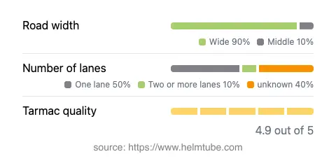
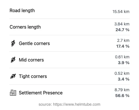
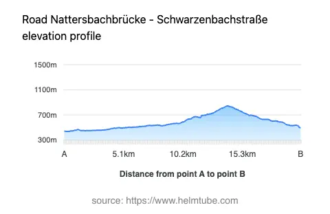
This route covers approximately 15.5 km (9.6 miles), with a surface of high-quality asphalt. The majority of the road is wide (about 84%), with a smaller portion being of medium width. Riders will encounter a mix of one-lane (about 47%) and two-lane (about 15%) sections, which requires attention during overtaking and when navigating through inhabited areas, which make up more than half of the route. The road is moderately curvy, offering a balance between straight stretches and gently curved segments, making it suitable for riders seeking a relaxed yet engaging ride. Elevation ranges from 439 m (1,440 ft) at its lowest point to 845 m (2,772 ft) at its highest, with the Pielachtaler Gscheid pass being the most prominent ascent. The route runs adjacent to the Pielach River for about 40% of its length, providing varied alpine scenery and occasional viewpoints along the way.
Mountain Pass and Natural Features
The highlight of this road is the crossing of the Pielachtaler Gscheid mountain pass, a notable feature in the Türnitzer Alpen. The pass is well-known among local motorcyclists for its accessible gradients and reliable road surface. The route also intersects the Türnitzer Alpen and the broader Alps range, offering a typical alpine riding environment. The Pielach River, which the road follows for a substantial distance, eventually flows into the Danube. Riders will also pass near the Talgraben valley, adding to the diversity of the landscape. Several viewpoints are accessible along the route, providing opportunities to pause and appreciate the surrounding mountains and valleys.
Practical Information: Closures, Tolls, and Regulations
There are no known permanent closures for motorcycles on the Nattersbachbrücke – Schwarzenbachstraße route. However, as with many alpine roads in Austria, temporary closures may occur during winter months due to snow or adverse weather conditions, particularly at higher elevations such as the Pielachtaler Gscheid pass. Riders are advised to check local traffic updates before planning a trip, especially outside the main riding season. Currently, there are no tolls or entrance fees required to use this road. Toll conditions may change in the future, so it is recommended to consult the ASFINAG website for the latest information on road tolls and vignettes in Austria. The maximum speed limit on this route is 70 km/h (43 mph) in some sections and 50 km/h (31 mph) in others, depending on proximity to inhabited areas and road conditions. Riders should observe posted speed limits and be mindful of local traffic regulations.
Attractions and Points of Interest
While the primary appeal of this route lies in its alpine setting and the experience of crossing the Pielachtaler Gscheid, riders can also enjoy several viewpoints along the way. The proximity to the Pielach River and the passage through the Türnitzer Alpen provide ample opportunities for photography and short stops. The settlements of Nattersbachbrücke and Schwarzenbachstraße offer basic amenities, while the surrounding region is known for its traditional Austrian countryside and hospitality. For those interested in exploring further, the Pielach River and the broader Alps region offer additional attractions and outdoor activities.
Explore the Region: Roads Close By
Discover more amazing roads located near the route featured in this article. The list below highlights nearby routes that are perfect for extending your ride or planning your next adventure.
Ride the Best: Austria’s Top Motorcycle Roads
These are the best motorbiking roads in Austria. The list below shows links to articles about top-rated motorcycle routes in the country. Explore the most popular roads in Austria and plan your next unforgettable motorbike adventure.