Exploring the In der Luft Pass: Kirchberggegend to Mank by Motorcycle
Locals know best!
If you travel this road often or live close by you will be given a chance to provide your valuable rating soon! Sign in and stay connected.Location and Overview of the In der Luft Pass Route
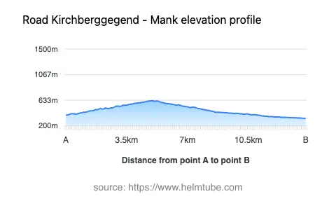
The Kirchberggegend – Mank road is situated in Lower Austria, connecting the village of Kirchberggegend with the town of Mank. The route crosses the Türnitzer Alpen, a subrange of the Northern Limestone Alps, and includes the In der Luft Pass, which reaches an elevation of 628 m (2,060 ft). The area is characterized by rolling hills, forested slopes, and agricultural land, with the road serving as a local connector between rural communities. An interactive map showing the route is available at the end of the article.
Road Characteristics and Riding Experience
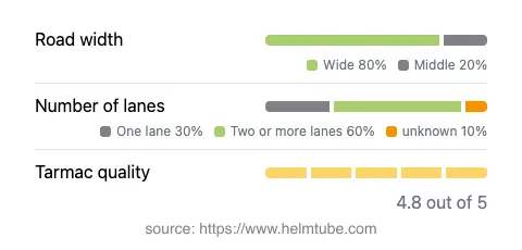
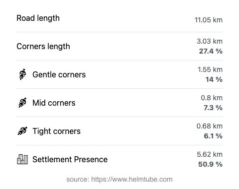
The Kirchberggegend – Mank route covers approximately 11.1 km (6.9 miles), with a surface of high-quality asphalt. The road is moderately curvy, offering a mix of gently winding sections and a few tighter bends, particularly near the In der Luft Pass. Surface quality is generally excellent, providing good grip and minimal irregularities. The road is predominantly wide (about 83%), with the remainder being of medium or narrow width. Most of the route features two lanes (about 63%), while some segments are single-lane, requiring caution when encountering oncoming traffic. The elevation ranges from 327 m (1,073 ft) at its lowest point to 626 m (2,054 ft) at its highest, with the pass itself slightly higher at 628 m (2,060 ft). Speed limits vary along the route, with sections posted at 50 km/h (31 mph), 70 km/h (43 mph), and 100 km/h (62 mph), depending on proximity to settlements and road geometry.
Mountain Pass and Surrounding Geography
The highlight of the route is the crossing of the In der Luft Pass, a lesser-known mountain pass in the Türnitzer Alpen. The pass is not widely recognized among international motorcyclists but is locally significant for connecting the valleys and settlements in this part of Lower Austria. The road also briefly passes through the Klausgraben valley, accounting for about 9% of its length. The surrounding Türnitzer Alpen are part of the larger Alps, offering a backdrop of wooded hills and occasional open vistas. The area is primarily rural, with limited tourist infrastructure, making it suitable for riders seeking a quieter, less trafficked experience. For more information on the Türnitzer Alpen, see Türnitzer Alpen.
Access, Closures, and Practical Considerations
The Kirchberggegend – Mank road, including the In der Luft Pass, is open to motorcycles and other vehicles throughout the year, weather permitting. There are no regular seasonal closures, but winter conditions (snow and ice) may render the pass temporarily impassable, especially after heavy snowfall. Riders should check local weather forecasts and road conditions before planning a winter journey. There are no known event-related closures affecting this route. The road does not currently have any tolls or entrance fees for motorcycles or other vehicles. However, toll conditions may change in the future. For up-to-date information on road tolls and fees in Austria, consult the official ASFINAG toll information website.
Nearby Attractions and Points of Interest
While the route itself is primarily functional, the surrounding region offers several attractions for those interested in extending their ride. The town of Mank provides basic amenities and serves as a gateway to the Mostviertel region, known for its traditional pear orchards and local gastronomy. The Türnitzer Alpen are suitable for hiking and nature observation, with trails accessible from nearby settlements. For those interested in exploring further, the broader Alps region offers numerous opportunities for outdoor activities. The area is less frequented by international tourists, making it an appealing option for riders seeking a more authentic Austrian countryside experience.
Explore the Region: Roads Close By
Discover more amazing roads located near the route featured in this article. The list below highlights nearby routes that are perfect for extending your ride or planning your next adventure.
Ride the Best: Austria’s Top Motorcycle Roads
These are the best motorbiking roads in Austria. The list below shows links to articles about top-rated motorcycle routes in the country. Explore the most popular roads in Austria and plan your next unforgettable motorbike adventure.