Riding the Pfaffensattel Pass: Mürzzuschlag to Rettenegg
Locals know best!
If you travel this road often or live close by you will be given a chance to provide your valuable rating soon! Sign in and stay connected.Location and Overview
The Mürzzuschlag – Rettenegg road is situated in the southeastern part of Austria, within the state of Styria. The route connects the town of Mürzzuschlag to the village of Rettenegg, crossing the Pfaffensattel Pass. The road lies within the broader context of the Alps, specifically intersecting the Steirische Voralpen, Randgebirge östlich der Mur, and Fischbacher Alpen. The region is characterized by its mountainous landscape, forested slopes, and a network of valleys, making it a favored area for outdoor activities. An interactive map showing the road can be found at the end of the article.
Road Characteristics and Riding Experience
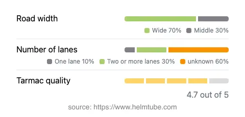
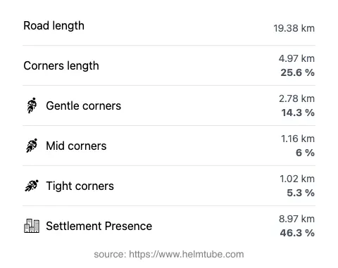
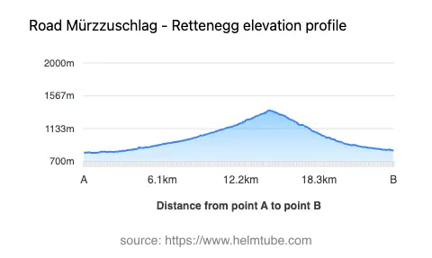
The Pfaffensattel Pass road extends for approximately 19.4 km (12.1 miles), with an elevation range from 815 m (2,674 ft) at its lowest point to 1,373 m (4,505 ft) at its highest. The route is predominantly wide (about 71%), with the remainder being of medium or narrow width. The surface is asphalt and is generally rated as very good, providing a comfortable and predictable riding experience. The road is moderately curvy, offering a mix of gently curved and more technical sections, particularly as it ascends and descends the pass. The majority of the route features two lanes, with a small portion being single-lane. Riders will encounter a variety of environments, with nearly half the road passing through inhabited areas, while the remainder traverses forested and alpine terrain. The road passes through several valleys, including Fröschnitzgraben, Steinergraben, Longsgraben, and Hasental, each contributing to the changing scenery and riding dynamics.
Mountain Pass and Surrounding Attractions
The highlight of this route is the crossing of the Pfaffensattel Pass, which sits at 1,372 m (4,501 ft). The pass is a well-known feature among local motorcyclists and is recognized for its accessibility and the panoramic views it offers of the surrounding Alps. The road also skirts the Rax-Schneeberg Group, a notable mountain group popular for hiking and mountaineering. The nearby town of Mürzzuschlag is historically significant as a railway hub and is home to the Südbahn Museum, which documents the region's railway heritage. Rettenegg, at the other end of the route, is a small village known for its tranquil setting and proximity to the Fischbacher Alpen, a range favored by hikers and nature enthusiasts.
Traffic, Speed Limits, and Seasonal Considerations
The road is subject to varying speed limits, with sections posted at 100 km/h (62 mph), 70 km/h (43 mph), and 50 km/h (31 mph), depending on proximity to settlements and road conditions. Traffic is generally moderate, with increased activity during weekends and holidays, particularly in the warmer months. The Pfaffensattel Pass is typically open to motorcycles throughout the riding season, but closures can occur during winter due to snow and adverse weather conditions. Riders are advised to check local traffic updates before planning a trip, as temporary closures may also result from maintenance work or special events.
Tolls, Fees, and Practical Information
There is currently no toll or entrance fee required to ride the Pfaffensattel Pass between Mürzzuschlag and Rettenegg. However, toll conditions may change in the future, and riders should verify the latest information before departure. For up-to-date details on road tolls and regulations in Austria, consult the official ASFINAG website. Fuel and basic services are available in Mürzzuschlag and Rettenegg, but options are limited along the pass itself. Riders are encouraged to prepare accordingly, especially when traveling outside of peak tourist seasons.
Explore the Region: Roads Close By
Discover more amazing roads located near the route featured in this article. The list below highlights nearby routes that are perfect for extending your ride or planning your next adventure.
Ride the Best: Austria’s Top Motorcycle Roads
These are the best motorbiking roads in Austria. The list below shows links to articles about top-rated motorcycle routes in the country. Explore the most popular roads in Austria and plan your next unforgettable motorbike adventure.