Riding the Soboth Pass: Exploring the Südsteirische Grenz Straße 3133
Locals know best!
If you travel this road often or live close by you will be given a chance to provide your valuable rating soon! Sign in and stay connected.Location and Geographic Context
The Soboth Pass Road, officially designated as the Südsteirische Grenz Straße 3133, is situated in southern Austria, connecting the regions near Dravograd and the broader Styrian border area. The route crosses the Koralpe and Lavanttaler Alps, forming part of the greater Alpine mountain system. The road’s proximity to the Karawanken-Karavanke UNESCO Global Geopark adds geological significance, while its passage through sparsely populated alpine terrain provides a sense of remoteness. The nearest major settlement to the starting point is Dravograd, located approximately 6.4 km (4 miles) away. An interactive map showing the full route of the Soboth Pass Road can be found at the end of this article.

Road Characteristics and Riding Experience
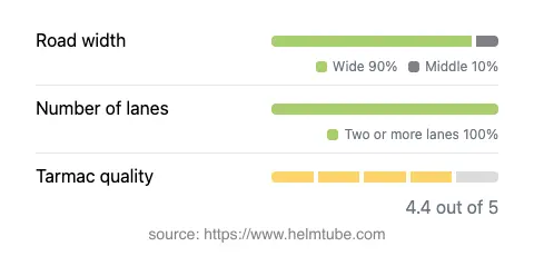
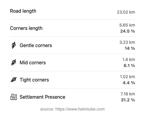
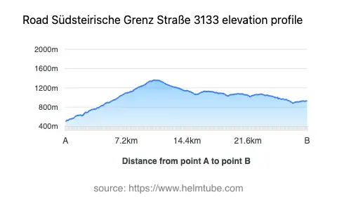
The Soboth Pass Road extends for approximately 23 km (14.3 miles), offering a moderately twisty riding experience. The road surface is asphalt and is generally rated as very good, providing reliable grip and comfort for motorcyclists. The route is predominantly wide (about 90%), with only brief sections that narrow, ensuring ample space for maneuvering. The road features two lanes throughout almost its entire length (about 90%), supporting safe overtaking and steady traffic flow. Elevation ranges from 507 m (1,663 ft) at its lowest point to 1,361 m (4,465 ft) at its highest, with the Soboth Pass itself reaching 1,347 m (4,419 ft). The maximum speed limit varies between 80 km/h (50 mph) and 100 km/h (62 mph), depending on the section. Approximately one-third of the route passes through inhabited areas, but the majority traverses open alpine landscapes. The road is also known for its viewpoints, offering opportunities to pause and appreciate the surrounding mountain scenery.


Mountain Pass and Natural Attractions
The highlight of this route is the Soboth Pass, a well-known crossing in the region. The pass is recognized for its elevation and the panoramic views it affords of the surrounding Alps. The road also passes through the Karawanken-Karavanke UNESCO Global Geopark, an area of geological and ecological interest. Riders will encounter several viewpoints along the way, which are popular stops for both motorcyclists and other travelers. The route’s alignment with the Koralpe and Lavanttaler Alps ensures a varied landscape, with forested slopes, alpine meadows, and occasional glimpses of distant peaks. For those interested in learning more about the region’s geology and natural history, the geopark’s official website provides additional resources.
Seasonal Closures and Road Access
The Soboth Pass Road is subject to seasonal closures, particularly during the winter months when snow and adverse weather conditions can make the route impassable. Typically, the road is closed to all traffic, including motorcycles, from late autumn until spring. Riders are advised to check current road conditions before planning a trip, as reopening dates can vary depending on weather patterns. There are no known event-related closures affecting this route on a regular basis, but temporary restrictions may occur due to maintenance or local events. For up-to-date information on road closures and conditions, consult the ASFINAG Traffic Reports.
Tolls, Fees, and Practical Information
Currently, there is no toll or entrance fee required to ride the Soboth Pass Road. However, toll conditions may change in the future, and it is advisable to verify the latest information before traveling. For comprehensive details on road tolls and entrance fees in Austria, including updates on any changes, refer to the ASFINAG Toll Information page. Riders should also be aware of general Austrian traffic regulations, including speed limits and safety requirements, to ensure a smooth and compliant journey.
Explore the Region: Roads Close By
Discover more amazing roads located near the route featured in this article. The list below highlights nearby routes that are perfect for extending your ride or planning your next adventure.
Ride the Best: Austria’s Top Motorcycle Roads
These are the best motorbiking roads in Austria. The list below shows links to articles about top-rated motorcycle routes in the country. Explore the most popular roads in Austria and plan your next unforgettable motorbike adventure.