Exploring the Flattnitzer Höhe Pass: A Motorcyclist’s Guide to Flattnitzer Straße 3335
Locals know best!
If you travel this road often or live close by you will be given a chance to provide your valuable rating soon! Sign in and stay connected.Location and Setting of Flattnitzer Straße 3335
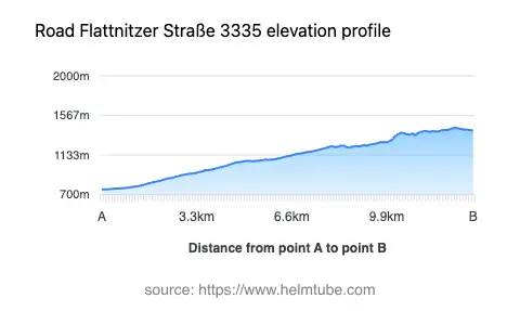
Flattnitzer Straße 3335 is situated in Austria, running through the Gurktaler Alps in the state of Carinthia. The road crosses the Flattnitzer Höhe, a mountain pass at an elevation of 1,429 m (4,688 ft), connecting the valleys on either side of the range. The route is embedded within the broader Gurk- und Lavanttaler Alpen and forms part of the extensive Alpine landscape. The road’s location places it within reach of several alpine settlements and offers access to viewpoints characteristic of the region. An interactive map showing the route of Flattnitzer Straße 3335 can be found at the end of this article.
Road Characteristics and Riding Experience
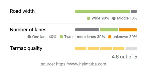
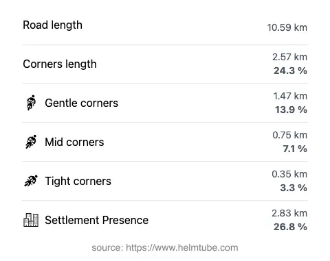
Flattnitzer Straße 3335 extends for approximately 10.6 km (6.6 miles), with the majority of its surface composed of high-quality asphalt. The road is moderately curvy, providing a mix of gently winding and more technical sections, making it suitable for riders seeking a balanced alpine experience. The surface quality is generally very good, with most of the route offering a smooth ride. The width of the road is predominantly wide (about 88%), allowing for comfortable passage, while some sections are of medium width. The road features both one-lane and two-lane segments, with one-lane stretches accounting for a significant portion (about 36%) and two-lane sections making up around 28%. The elevation ranges from 758 m (2,487 ft) at its lowest point to 1,430 m (4,692 ft) at its highest, with the Flattnitzer Höhe pass itself reaching 1,429 m (4,688 ft). The maximum speed limit along the route is 50 km/h (31 mph), reflecting the technical nature and safety considerations of mountain riding.
Mountain Pass and Surrounding Attractions
The highlight of this route is the crossing of the Flattnitzer Höhe, a notable mountain pass in the Gurktaler Alps. The pass is a well-known waypoint for travelers and offers panoramic views of the surrounding alpine landscape. Along the route, riders will encounter viewpoints that provide opportunities to appreciate the natural beauty of the region. The road’s passage through the Gurktal Alps further enhances its appeal, as the area is recognized for its rugged terrain and alpine flora. While the road itself is not heavily urbanized, approximately 26.8% of its length passes through inhabited areas, offering occasional glimpses of local settlements and traditional alpine architecture.
Seasonal Accessibility and Road Closures
Flattnitzer Straße 3335, including the Flattnitzer Höhe pass, is subject to seasonal closures due to winter weather conditions. The pass is typically closed to all traffic, including motorcycles, during periods of heavy snowfall, which can extend from late autumn to early spring. Riders are advised to check current road conditions before planning a trip, as closures may vary depending on weather patterns and maintenance schedules. There are no known event-related closures specific to this route, but temporary restrictions may occur due to roadworks or local events. Up-to-date information on road closures can be obtained from the ASFINAG Traffic Reports website.
Tolls, Fees, and Practical Information
Currently, there is no toll or entrance fee required for motorcycles to use Flattnitzer Straße 3335 or to cross the Flattnitzer Höhe pass. However, toll conditions may change in the future, and riders should verify the latest information before departure. For comprehensive details on road tolls and entrance fees in Austria, including updates and regulations for motorcycles, refer to the ASFINAG Toll Information page. Riders should also ensure their vehicles comply with Austrian road regulations, including the use of appropriate safety gear and adherence to posted speed limits.
Explore the Region: Roads Close By
Discover more amazing roads located near the route featured in this article. The list below highlights nearby routes that are perfect for extending your ride or planning your next adventure.
Ride the Best: Austria’s Top Motorcycle Roads
These are the best motorbiking roads in Austria. The list below shows links to articles about top-rated motorcycle routes in the country. Explore the most popular roads in Austria and plan your next unforgettable motorbike adventure.