Exploring the Puchenstubener Straße and Wastl am Wald Pass: A Motorcyclist’s Guide
Locals know best!
If you travel this road often or live close by you will be given a chance to provide your valuable rating soon! Sign in and stay connected.Location and Overview of Puchenstubener Straße
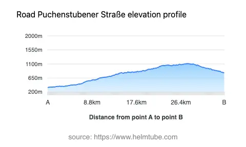
Puchenstubener Straße is situated in the Austrian state of Lower Austria, connecting the settlements of Lassingrotte, Christian Haller Straße, and Neubruck. The road lies within the broader region of the Türnitzer Alpen and skirts the Ybbstaler Alpen, both subranges of the Northern Limestone Alps. The nearest major town to the starting point is Scheibbs, located approximately 2.8 km (1.7 miles) away. The route is characterized by its passage through mountainous terrain, including the notable Wastl am Wald pass at an elevation of 1,110 m (3,642 ft). An interactive map showing the road can be found at the end of the article.
Road Characteristics and Riding Experience
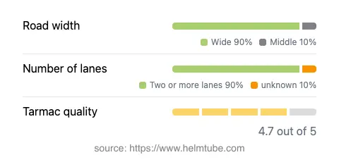
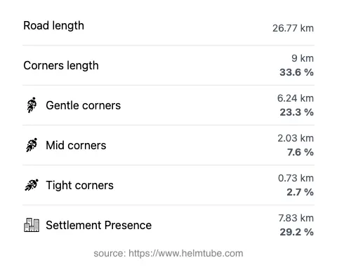
The Puchenstubener Straße extends for approximately 26.8 km (16.7 miles), with the majority of the route featuring wide, two-lane asphalt. The road surface is generally of high quality, providing a smooth ride for most motorcycles. Riders will encounter a gently curved alignment, making it suitable for those who prefer less technical riding while still enjoying the dynamics of alpine roads. The route passes through a mix of inhabited areas (about 29%) and open countryside, offering a variety of visual experiences. The elevation ranges from 344 m (1,129 ft) at its lowest point to 1,110 m (3,642 ft) at the Wastl am Wald pass, providing moderate altitude changes without extreme gradients. The road also briefly runs adjacent to the Klamm and Übelbachgraben valleys, though these sections are limited in length.
Wastl am Wald Pass and Surrounding Attractions
The highlight of the route is the crossing of the Wastl am Wald pass, a lesser-known but historically significant mountain pass in the Türnitzer Alpen. The pass itself is surrounded by dense forests and offers occasional views of the surrounding peaks. The Türnitzer Alpen region is known for its hiking trails and natural beauty, with opportunities to explore the nearby Türnitzer Alpen and the adjacent Ybbstaler Alpen. While the road does not pass directly through major tourist attractions, the rural settlements along the way, such as Neubruck, offer a glimpse into traditional Austrian village life. Riders interested in extending their journey can explore the town of Scheibbs, known for its historic architecture and riverside setting.
Seasonal Closures, Road Access, and Regulations
The Puchenstubener Straße, including the Wastl am Wald pass, is generally open to motorcyclists throughout the year. However, due to its elevation and alpine location, winter closures are possible, especially during periods of heavy snowfall or adverse weather. Riders are advised to check local traffic reports or the ASFINAG traffic reports for up-to-date information on road conditions and potential closures. There are no known restrictions specific to motorcycles, but standard Austrian traffic regulations apply, including speed limits of 50 km/h (31 mph) in inhabited areas, 70 km/h (43 mph) in some sections, and up to 100 km/h (62 mph) on open stretches. Temporary closures may occur due to maintenance or local events, so advance planning is recommended.
Tolls, Fees, and Practical Information
Currently, there are no tolls or entrance fees required for motorcycles or other vehicles on the Puchenstubener Straße or the Wastl am Wald pass. Riders should note that toll conditions may change in the future, and it is advisable to consult official sources for the latest information. For comprehensive details on road tolls and vignettes in Austria, refer to the ASFINAG toll information page. Fuel stations and services are limited along the route, so it is recommended to refuel in larger towns such as Scheibbs before embarking on the journey.
Explore the Region: Roads Close By
Discover more amazing roads located near the route featured in this article. The list below highlights nearby routes that are perfect for extending your ride or planning your next adventure.
Ride the Best: Austria’s Top Motorcycle Roads
These are the best motorbiking roads in Austria. The list below shows links to articles about top-rated motorcycle routes in the country. Explore the most popular roads in Austria and plan your next unforgettable motorbike adventure.