Exploring the Mistelbach–Zistersdorf Route: A Motorcyclist’s Guide
Locals know best!
If you travel this road often or live close by you will be given a chance to provide your valuable rating soon! Sign in and stay connected.Location and Regional Context
The Mistelbach–Zistersdorf route is situated in the northeastern part of Austria, within the state of Lower Austria. The road links the towns of Mistelbach and Zistersdorf, traversing the Weinviertel, a region known for its rolling vineyards and agricultural landscapes. The route passes through several settlements, including Bahnstraße, Gaiselberger Straße, Hauptstraße, Schlossberggasse, Obersulzerstraße, Hobersdorfer Straße, Wiedengasse, and Kaiserstraße. This area is characterized by gentle hills and open fields, providing a relaxed riding environment. An interactive map showing the road can be found at the end of the article.
Road Details and Riding Experience
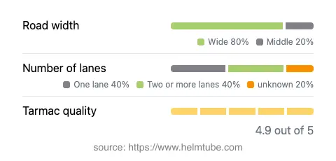
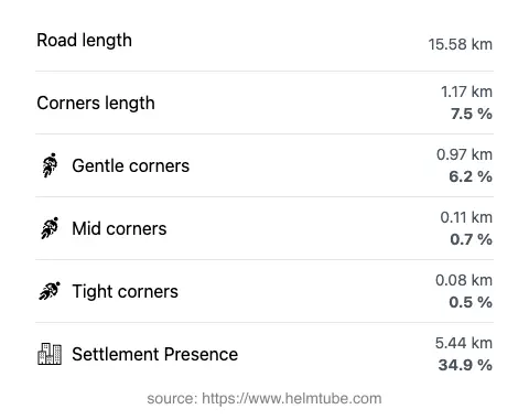
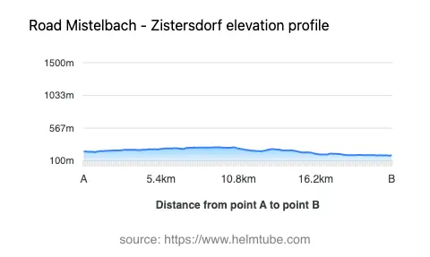
The Mistelbach–Zistersdorf road covers a distance of approximately 15.6 km (9.7 miles), with elevations ranging from 177 m (581 ft) to 294 m (965 ft). The road surface is asphalt and is rated as excellent, offering a smooth ride for motorcycles. The route is predominantly wide (about 82%), with some sections of medium width and a minimal proportion that is narrow. Most of the road features one or two lanes, with one-lane sections making up about 43% and two-lane sections about 37%. The road is not particularly curvy, with gentle bends and long straight stretches, making it suitable for riders who prefer a relaxed pace over technical cornering. Approximately 34.9% of the route passes through inhabited areas, so riders should be mindful of local traffic and speed regulations.
Speed Limits and Traffic Considerations
Speed limits along the Mistelbach–Zistersdorf route vary, with posted limits of 100 km/h (62 mph), 70 km/h (43 mph), 60 km/h (37 mph), 50 km/h (31 mph), and 30 km/h (19 mph) depending on the section and proximity to settlements. Riders should pay close attention to signage, especially when entering towns or villages, where lower speed limits are enforced. The road is generally quiet, with moderate local traffic, particularly during peak commuting hours. The excellent surface quality and wide sections contribute to a comfortable and predictable riding experience.
Road Closures, Seasonal Access, and Fees
There are no known restrictions or closures for motorcycles on the Mistelbach–Zistersdorf route. The road remains open year-round, as it does not traverse high-altitude or mountainous terrain that would typically be subject to winter closures. No event-related closures have been reported. Currently, there are no tolls or entrance fees required to use this road. Riders should be aware that toll conditions may change in the future. For up-to-date information on road tolls and entrance fees in Austria, refer to ASFINAG.
Points of Interest and Attractions
While the Mistelbach–Zistersdorf route is primarily a connector through rural Weinviertel, both terminal towns offer attractions worth exploring. Mistelbach is known for its regional museums and cultural events, while Zistersdorf features historic architecture and local wine cellars. The surrounding Weinviertel region is renowned for its vineyards and wine tourism, making it an appealing destination for riders interested in local gastronomy and culture. The route itself provides access to these attractions and serves as a gateway to further exploration in Lower Austria.
Explore the Region: Roads Close By
Discover more amazing roads located near the route featured in this article. The list below highlights nearby routes that are perfect for extending your ride or planning your next adventure.
Ride the Best: Austria’s Top Motorcycle Roads
These are the best motorbiking roads in Austria. The list below shows links to articles about top-rated motorcycle routes in the country. Explore the most popular roads in Austria and plan your next unforgettable motorbike adventure.